Past IEM Features tagged: thunder
Thunder Season
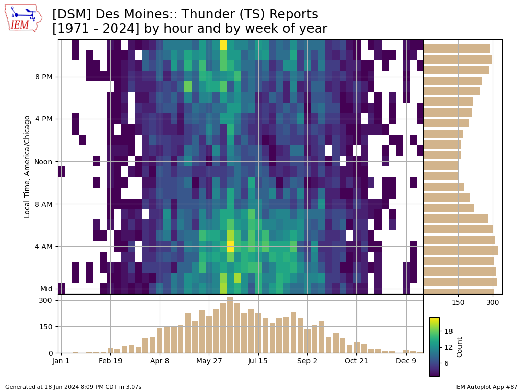
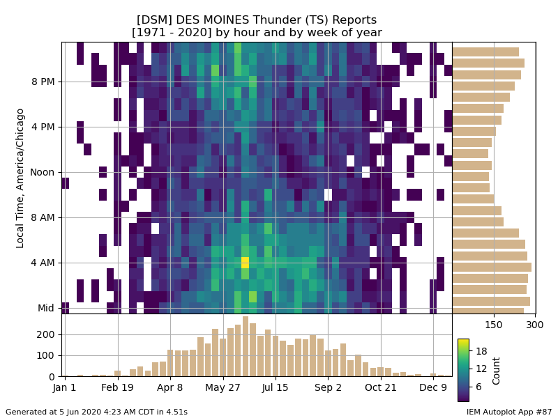
06 Mar 2026 05:30 AMThunderstorms rolled into Iowa late Thursday night and will abound today bringing much needed rainfall to the state. Having such storms during the first week of March is nothing too exceptional as shown by the featured chart. The chart presents a heatmap of Des Moines airport weather reports of thunder by week of the year and by hour of the day. The side bar charts present the histograms for each. The chart shows an increase in such activity starting about mid February and roughly increasing each week until peaking in mid June. The chart nicely shows how most of the thunder reports are during the night time hours for central Iowa as activity is often driven by the "low level jet" persisting thunderstorm complexes that develop over the plains and then move east overnight. The early spring and late fall activity shows less of a strong overnight signal as these time periods are more dominated by larger scale low pressure systems that impact the state and more tied to daylight heating driving thunderstorm activity.
Voting:
Good: 14
Bad: 0
Tags: thunder
Monthly Thunder Hours
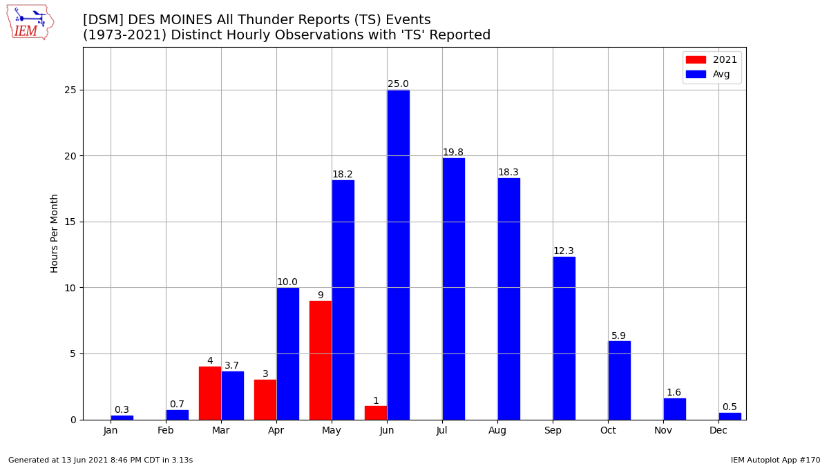
14 Mar 2025 05:30 AMWith strong to likely severe thunderstorms forecast over Iowa Friday, it is a good time to check in on the frequency of thunder being reported at the Des Moines airport weather station. Based on available hourly or better reports, the featured chart presents the monthly number of distinct hours with at least one thunder observation. The blue bars are the simple long term average and red bars are the year to date. The annual cycle is obvious with non zero values still found during the cold season. March is just the start of thunderstorm season with about triple the amount of hours, on average, found during April.
Voting:
Good: 22
Bad: 1
Abstain: 1
Tags: thunder
June Peak of Thunder
19 Jun 2024 05:30 AMWhile not all parts of the state have seen thunderstorms over the past few hot and steamy days, storms have been frequent each day and have continued overnight and into this morning. The featured chart presents the frequency of having the automated weather station at the Des Moines Airport report thunder. Frequencies are binned by week of the year and hour of the day. The middle of June is the approximate peak in frequency along with the 3-4 AM early morning hours, so the ongoing storms this morning fit this plot well. It is interesting to see the minimum during the noon hour, which some may think as counter-intuitive as that is the approximate hour of peak heating (quasi solar noon). Storms tend to develop after the accumulated effect of the day's worth of heating and associated erosion of an elevated layer of warm air. For Iowa, the overnight maximum is related to the rotation of the "low level jet" with peak transport of unstable low level air into the state during the early morning hours.
Voting:
Good: 14
Bad: 0
Tags: thunder
500hPa Heights Falls + Thunder Reports
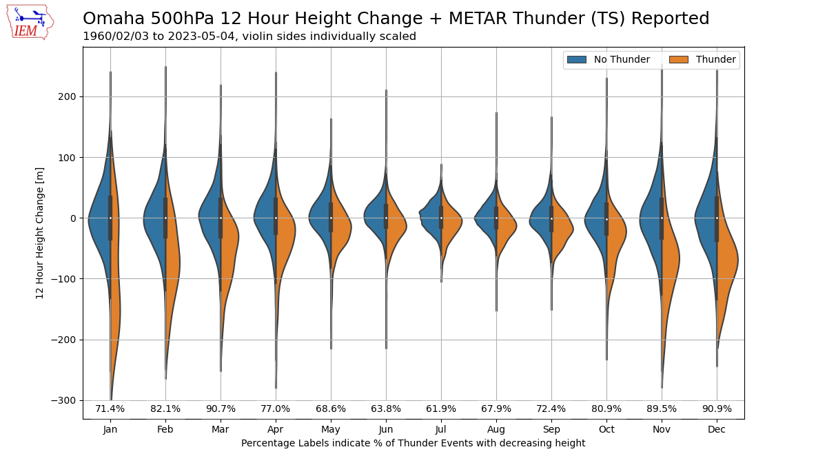
05 May 2023 05:30 AMWith hopefully a return to thunderstorms in store over the coming days, the featured chart takes a bit of a deep dive into some meteorology regarding thunderstorm forecasting. A vital set of observations to understand the state of the atmosphere are the twice daily soundings taken by the NWS. These soundings report observations at mandatory pressure levels as the balloons ascend to help produce consistent spatial analyses over the globe. Perhaps the most important pressure level for meteorologists is 500 hPa, which is approximately a half way point (from a mass perspective) and often can provide insights into atmospheric stability and steering currents to forecast storms. The vertical height above sea level and how it is changing with time can yield first pass assumptions on if the air in the column is rising or sinking. For storms, rising air is desired. So the featured chart compares the 12 hour change in 500 hPa height and if thunder was observed over this same 12 hour period based on sounding and METAR/airport data from Omaha, NE. The data is partitioned by month and if thunder was or wasn't observed. The data is presented as split violin plots, so to give a sense of the distribution of the values. An important note is that the two sides are not equally scaled. The labels near the bottom indicate the percentage of thunder cases that coincided with decreasing heights. Whew! So what insight does this chart provide? First, it is clear that decreasing heights are dominant for thunder cases during the cold season. They are less coincident during the summer season, how could that be? The scale of the storm systems involved is the explanation as cold season thunder activity is associated with large storm systems that will be easily sampled by the twice daily soundings. During the summer time, thunderstorm complexes are smaller scale and driven by more subtle features in the atmosphere, which are not easily diagnosed by twice daily soundings.
Voting:
Good: 15
Bad: 0
Abstain: 1
Tags: meteorology sounding thunder
Just One Hour
13 Jun 2021 08:44 PMSome rainfall was able to make it into western Iowa this past Friday, but did not amount to a whole lot. Interestingly, it was able to muster a thunder report from the airport weather station in Des Moines, which was the first such report this month. It only amounted to 0.02 inches though for the site! Anyway, June is the peak of thunder reports for Iowa with the featured chart presenting the 2021 hourly reports for Des Moines along with the simple average climatology with data back to 1973. There are caveats galore with a plot like this and how observation techniques for thunder have changed over the years, but the 2021 story is pretty clear. We should have seen many more thunder reports for this month, May and even April.
Voting:
Good: 18
Bad: 1
Tags: thunder
Awaiting August Thunder
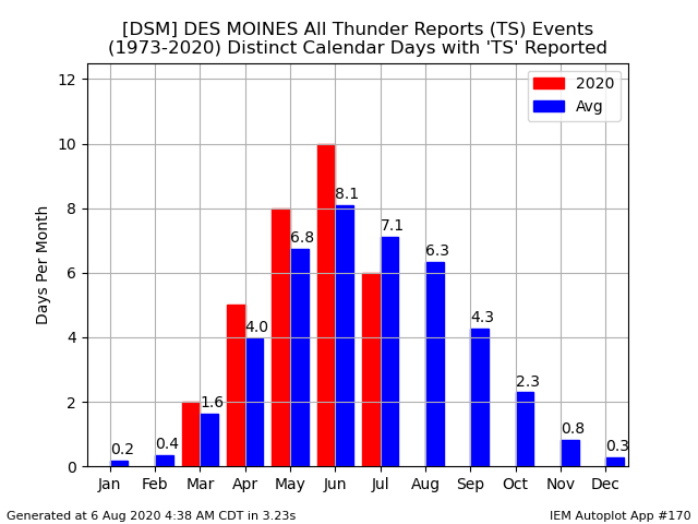
06 Aug 2020 04:46 AMThe featured chart presents the monthly climatology and 2020 total number for distinct days with METAR observations from the Des Moines Airport reporting thunder as a present weather condition. Our total for August 2020 remains at zero days and follows the below average total for July. Dry weather has dominated this period, so it makes sense to have fewer thunderstorms as well. A few chances of thunderstorms and associated rainfall is in the forecast, so there is at least some optimism rain will fall over Iowa during the coming days.
Voting:
Good: 10
Bad: 1
Tags: thunder
Peak Thunder Season
05 Jun 2020 04:38 AMWith rumbling thunderstorms living up to their name this Friday morning, the featured chart shows the climatology of thunder reports based on the Des Moines Airport weather station. The chart is a histogram showing the frequency by week of the year and hour of the day. For hour of the day, it nicely shows two peaks at about 9 PM and at 4 AM (coincidentally when thunder is occurring now this morning!). The 9 PM peak represents the thunderstorms that fire during the late afternoon hours thanks to intense heating and instability that builds during the day. The 4 AM peak is driven by something called the Low Level Jet, which feeds thunderstorm complexes into the early morning hours that roll through Iowa during the summertime. For week of the year, the weeks of June are the peak which is a function of having the highest combination of instability and shear.
Voting:
Good: 16
Bad: 0
Tags: thunder
Peak Thunder
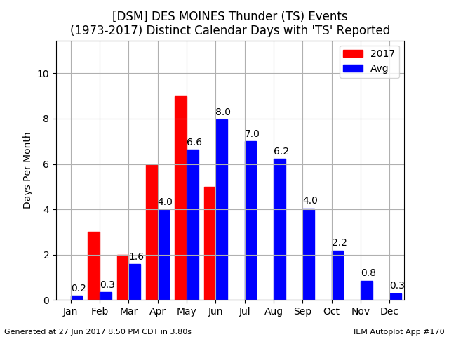
28 Jun 2017 05:34 AMThe featured chart displays the average number of calendar days each month during which at least one automated thunder report was reported at the Des Moines Airport. Based on the averages, the month of June represents peak thunder for the year. So far, this year's total is a bit below average but a number of forecasted stormy days remain. Of course, there are caveats with a plot like this as automated reporting methods have changed over the years. So a value of eight days in June represents about one out of every four days.
Voting:
Good: 10
Bad: 0
Tags: thunder
Rare December Thunder
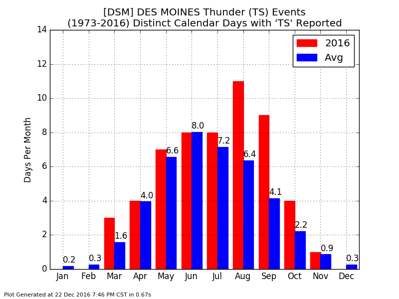
23 Dec 2016 06:15 AMAfter the ongoing snow storm this Friday, a more powerful storm system arrives for Christmas Sunday. Warmer air is expected to flood the state ahead of the storm system and conditions may be favorable for thunderstorms! How far is having thunder in December? The featured chart presents the number of distinct calendar days each month that thunder was reported by the Des Moines Airport weather station. The red bars are the total for 2016 and the blue bars are long term averages. The 0.3 days presented on average for December would equate to having one event every 3 years.
Voting:
Good: 11
Bad: 0
Tags: thunder
Thunder by Hour
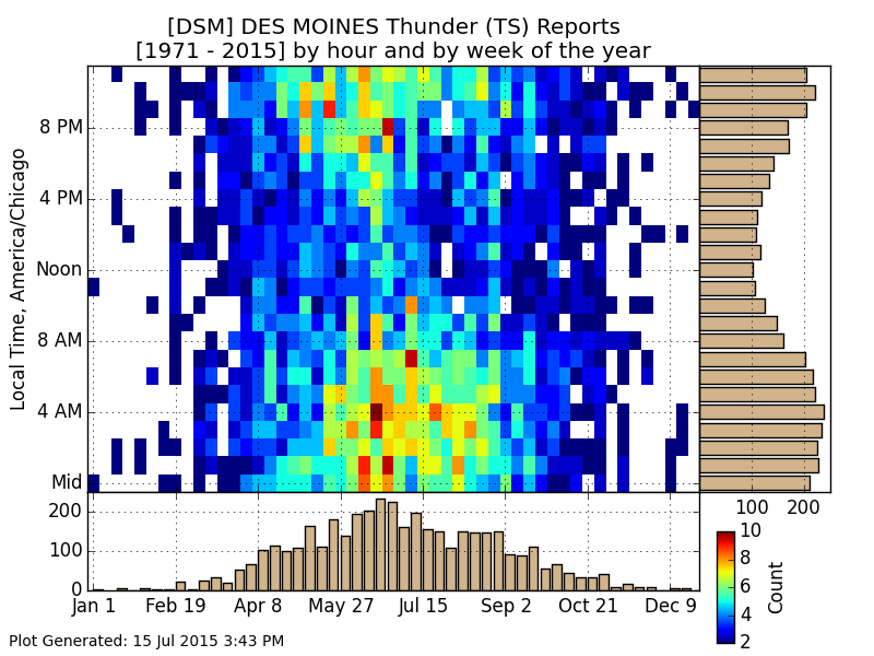
16 Jul 2015 05:44 AMA complex of thunderstorms is currently rumbling over the state this Thursday morning. The Des Moines weather station has reported thunder for most of the overnight hours today. The featured chart presents the frequencies of thunder being reported by the Des Moines Airport weather station. The bottom and right side bar charts display a histogram of these reports by week of year and hour respectively. The early morning hours are the favored time for thunder reports as much of Iowa's summertime precipitation is driven by a phenomena called the 'Low Level Jet'. This jet feeds unstable air into Iowa during the overnight hours.
Voting:
Good: 18
Bad: 8
Abstain: 5
Tags: thunder
Thunderstorm and Winds
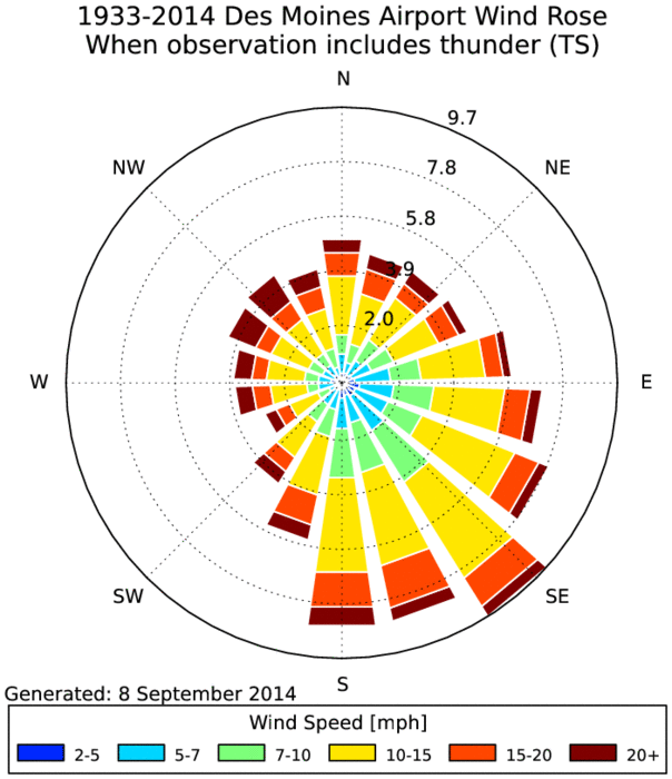
09 Sep 2014 05:05 AMThe Des Moines Airport automated weather station reported a thunderstorm yesterday afternoon along with southeasterly winds. The featured wind rose presents the wind speed and direction during which a thunderstorm is reported within the present weather observation of the site. Thunderstorms are driven by instability in the atmosphere, which is the combination of warm and moist air. Our primary source of that type of air is from the southeast, so it makes sense to see that wind direction dominate the frequency shown in the wind rose. While Iowa gets the warmest air from the southwesterly directions, that air is typically much drier and thus less likely to help promote thunderstorm development. More thunderstorms are expected today.
Voting:
Good: 18
Bad: 10
Abstain: 8
Tags: asos thunder


