IEM Reanalysis (IEMRE)
IEM Reanalysis is an effort to provide a regular dataset of Iowa Environmental Data without many of the problems associated with single site observations. The IEM will continue to provide single site observational data, but for some purposes, this dataset will be easier to work with. No dataset is perfect and this dataset is provided without warranty.
The IEM Reanalysis is nothing special. It was cool maybe 15 years ago, but now days there are superior products available. Use those instead!
- Why do this?
Previously, the IEM has only provided raw observations with limited quality control checks in place. Quality control is hard! Many times, users are simply looking for something "close" and perhaps not as perfect as high quality sensor observations can be. Producing a gridded analysis is one way to produce a dataset from point observations which can be sampled as a means of spatial interpolation. - Isn't this a duplication of effort?
While there are other "reanalysis" type projects out there with data freely available, many times their data does not update in near real-time and does not include many of the datasets the IEM uniquely collects.
Having said that, here are some alternatives:
ERA5Land
DayMet
GridMet
PRISM
Product Changes
- 4 Jan 2023: Near realtime solar radiation is sourced from the HRRR model. For dates prior to 8 days ago, it is sourced from ERA5Land. This is a change as it used to be sourced from MERRAv2. It will take a number of days to update the archive to use this new source.
- 1 May 2018: Grid domain expanded to cover CONUS. It will take a while to fully populate the grids. At the moment, just the previous midwestern US data is available. Grid resolution increased to 0.125x0.125 degree.
Data Flow
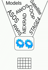
1. Input Datasets
- NCEP Stage IV Precipitation
This is an hourly gridded product with precipitation estimates derived by RADAR and then bias corrected by gauge data. The IEM caches the grib data and makes hourly plots available here. - MRMS Precipitation
Currently, this is only used to populate a daily total in a dedicated netcdf file. - ASOS/AWOS Daily Summaries
- NWS Daily Climate Summaries
- HRRR/MERRA/NARR Daily Solar Radiation
- NWS COOPerative Observations
- Manually QC'd Iowa COOP data from Iowa's State Climatologist
- NCDC QC'd COOP Data
2. IEM ReAnalysis Gridded Datasets
- Daily Maps of Gridded Variables
View a smoothed or gridded plot of IEMRE data - Maps of Precipitation
Generate maps for a single day or multiple days. - Download the raw NetCDF Files here.
3. Climodat Station Data
The location of the IEM Longterm tracked climate stations are used to sample from the IEMRE grid to produce daily values of high / low temperature, precipitation, snowfall, snow depth, and radiation. For some stations, a direct copy of the corresponding ASOS station data is used.
- Climodat Reports
These are pre-generated reports answering many of the commonly asked climatology questions.
Hourly Data Sources
Yearly netcdf files since 1950, with updates at about 10 after the hour. Since we want real-time data, some of these model sources are not available immediately, so the denoted intermediate source fills the gap until the final source is available.
| Variable | Intermediate Source | Final Source |
|---|---|---|
| Precipitation | Stage IV | 1997+ Stage IV adjusted by PRISM
1950-1997 ERA5-Land |
| 2m Air Temperature
2 m Dew Point Temperature 10m Wind Speed |
Crude ASOS grid analysis | 2010+: RTMA, once available
1950-2010 ERA5-Land |
| 4 inch (cough 0-10 or 0-7cm) Soil Temperature | HRRR | 1950+: ERA5-Land |
| Sky Coverage | Crude ASOS grid analysis | Crude ASOS grid analysis |
Daily Data Sources
Yearly netcdf files since 1893. Some of these variables are directly sourced from the hourly grids above. The concept of a daily variable is a bit nebulous, but is intended to be a 6 to 6 UTC period.
| Variable | Intermediate Source | Final Source |
|---|---|---|
| High/Low 4 inch (cough 0-10 or 0-7cm) Soil Temperature | HRRR | 1950+: ERA5-Land |
| Average 2m Dew Point Temperature | Simple average of hourly RTMA | 2010+: RTMA, once available
1950-2010 ERA5-Land |
| 24 Hour Snowfall at 12 UTC | NOHRSC Snowfall | 2008+: NOHRSC
Prior: COOP snowfall analysis. |
Data Access
Here are some JSON web services you may try.
MultiDay Request
================
Form: https://mesonet.agron.iastate.edu/iemre/multiday/{YYYY-MM-DD::date1}/{YYYY-MM-DD::date2}/{LAT}/{LON}/json
Example: https://mesonet.agron.iastate.edu/iemre/multiday/2010-05-01/2010-09-30/42.54/-96.40/json
Single Day Request
=======++=========
Form: https://mesonet.agron.iastate.edu/iemre/daily/{YYYY-MM-DD}/{LAT}/{LON}/json
Example: https://mesonet.agron.iastate.edu/iemre/daily/2010-05-01/42.54/-96.40/json
Single Day's Hourly (CDT/CST) Request
=======++=========
Form: https://mesonet.agron.iastate.edu/iemre/hourly/{YYYY-MM-DD}/{LAT}/{LON}/json
Example: https://mesonet.agron.iastate.edu/iemre/hourly/2010-05-01/42.54/-96.40/json
Raw Data Access
The IEM makes extensive use of the NetCDF file format to store these gridded datasets. You can find individual web directories for various IEMRE related datasets:
- IEMRE Files
- ERA5Land Hourly Netcdf Files
- MRMS CST Daily Netcdf Files
- NCEP Stage IV Hourly Data
- Oregon State PRISM Daily Data
Publications Citing IEM Data (View All)
These are the most recent 10 publications that have cited the usage of data from this page. This list is not exhaustive, so please let us know if you have a publication that should be added.
- Dickey, L., C. Rehmann, et al. 2024, Evaluation of a Pretreatment Intake System for Reducing Particulate Loading to a Bioretention Cell. J. Sustainable Water Built Environ. https://ascelibrary.org/doi/epdf/10.1061/JSWBAY.SWENG-589
- Calderon, I. 2024,Developing a Data-driven Water Quality Prediction Tool at the Event Scale for Tile-drained Agriculture-dominated Catchments. Iowa State University Thesis https://www.proquest.com/docview/3066356444
- Laurent, A., Cleveringa, A., Fey, S. et al. Late-season corn stalk nitrate measurements across the US Midwest from 2006 to 2018. Sci Data 10, 192 . https://doi.org/10.1038/s41597-023-02071-9
- Walker, V., V. Wallace, et al. 2023, From field observations to temporally dynamic soil surface roughness retrievals in the U.S. Corn Belt. Remote Sensing of the Environment. Volume 287. https://doi.org/10.1016/j.rse.2023.113458
- Shahhosseini, M., G. Hu, et al. 2021, Coupling machine learning and crop modeling improves crop yield prediction in the US Corn Belt. Scientific Reports 11, Article Number:1606 https://doi.org/10.1038/s41598-020-80820-1
- Kyveryga, P., P. Caragea, et al. 2013, Predicting Risk from Reducing Nitrogen Fertilization Using Hierarchical Models and On-Farm Data. Agronomy Journal. Volume 105, Issue 1 https://doi.org/10.2134/agronj2012.0218