National Weather Service Raw Text Product
Displaying AFOS PIL: SEL9 Product Timestamp: 2025-04-30 20:25 UTC
Previous in Time Latest Product Next in Time
View All KWNS Products for 30 Apr 2025 View All SEL Products for 30 Apr 2025 View As Image Download As Text
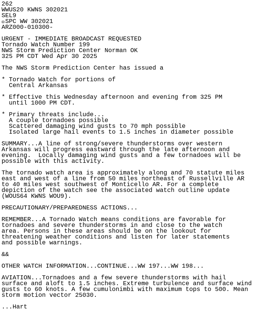
262
WWUS20 KWNS 302021
SEL9
SPC WW 302021
ARZ000-010300-

URGENT - IMMEDIATE BROADCAST REQUESTED
Tornado Watch Number 199
NWS Storm Prediction Center Norman OK
325 PM CDT Wed Apr 30 2025

The NWS Storm Prediction Center has issued a

* Tornado Watch for portions of
  Central Arkansas

* Effective this Wednesday afternoon and evening from 325 PM
  until 1000 PM CDT.

* Primary threats include...
  A couple tornadoes possible
  Scattered damaging wind gusts to 70 mph possible
  Isolated large hail events to 1.5 inches in diameter possible

SUMMARY...A line of strong/severe thunderstorms over western
Arkansas will progress eastward through the late afternoon and
evening.  Locally damaging wind gusts and a few tornadoes will be
possible with this activity.

The tornado watch area is approximately along and 70 statute miles
east and west of a line from 50 miles northeast of Russellville AR
to 40 miles west southwest of Monticello AR. For a complete
depiction of the watch see the associated watch outline update
(WOUS64 KWNS WOU9).

PRECAUTIONARY/PREPAREDNESS ACTIONS...

REMEMBER...A Tornado Watch means conditions are favorable for
tornadoes and severe thunderstorms in and close to the watch
area. Persons in these areas should be on the lookout for
threatening weather conditions and listen for later statements
and possible warnings.

&&

OTHER WATCH INFORMATION...CONTINUE...WW 197...WW 198...

AVIATION...Tornadoes and a few severe thunderstorms with hail
surface and aloft to 1.5 inches. Extreme turbulence and surface wind
gusts to 60 knots. A few cumulonimbi with maximum tops to 500. Mean
storm motion vector 25030.

...Hart