National Weather Service Raw Text Product
Displaying AFOS PIL: SEL8 Product Timestamp: 2025-04-30 18:05 UTC
Previous in Time Latest Product Next in Time
View All KWNS Products for 30 Apr 2025 View All SEL Products for 30 Apr 2025 View As Image Download As Text
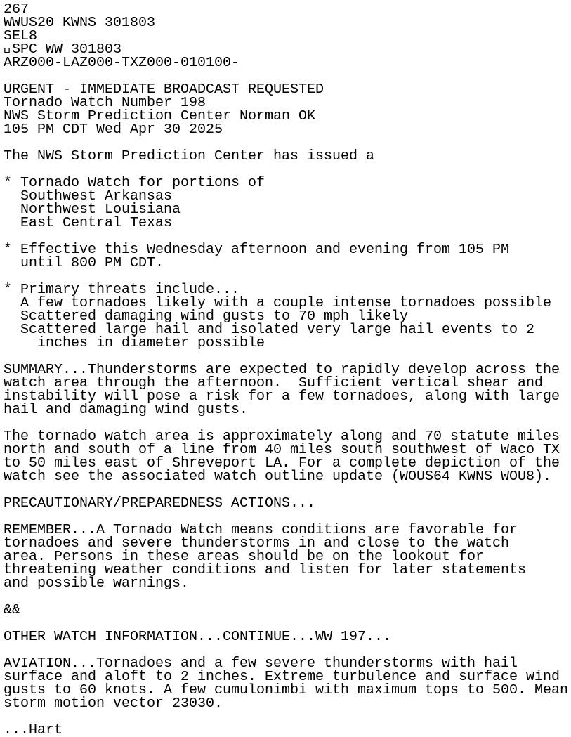
267
WWUS20 KWNS 301803
SEL8
SPC WW 301803
ARZ000-LAZ000-TXZ000-010100-

URGENT - IMMEDIATE BROADCAST REQUESTED
Tornado Watch Number 198
NWS Storm Prediction Center Norman OK
105 PM CDT Wed Apr 30 2025

The NWS Storm Prediction Center has issued a

* Tornado Watch for portions of
  Southwest Arkansas
  Northwest Louisiana
  East Central Texas

* Effective this Wednesday afternoon and evening from 105 PM
  until 800 PM CDT.

* Primary threats include...
  A few tornadoes likely with a couple intense tornadoes possible
  Scattered damaging wind gusts to 70 mph likely
  Scattered large hail and isolated very large hail events to 2
    inches in diameter possible

SUMMARY...Thunderstorms are expected to rapidly develop across the
watch area through the afternoon.  Sufficient vertical shear and
instability will pose a risk for a few tornadoes, along with large
hail and damaging wind gusts.

The tornado watch area is approximately along and 70 statute miles
north and south of a line from 40 miles south southwest of Waco TX
to 50 miles east of Shreveport LA. For a complete depiction of the
watch see the associated watch outline update (WOUS64 KWNS WOU8).

PRECAUTIONARY/PREPAREDNESS ACTIONS...

REMEMBER...A Tornado Watch means conditions are favorable for
tornadoes and severe thunderstorms in and close to the watch
area. Persons in these areas should be on the lookout for
threatening weather conditions and listen for later statements
and possible warnings.

&&

OTHER WATCH INFORMATION...CONTINUE...WW 197...

AVIATION...Tornadoes and a few severe thunderstorms with hail
surface and aloft to 2 inches. Extreme turbulence and surface wind
gusts to 60 knots. A few cumulonimbi with maximum tops to 500. Mean
storm motion vector 23030.

...Hart