IEM Provided NCEP HRRR Forecated Simulated Reflectivity
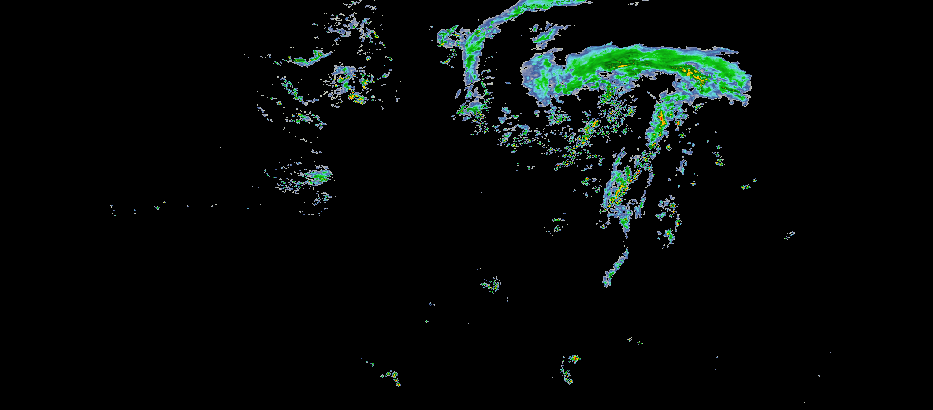
Latest HRRR 1 Hour Forecast (
REFD)
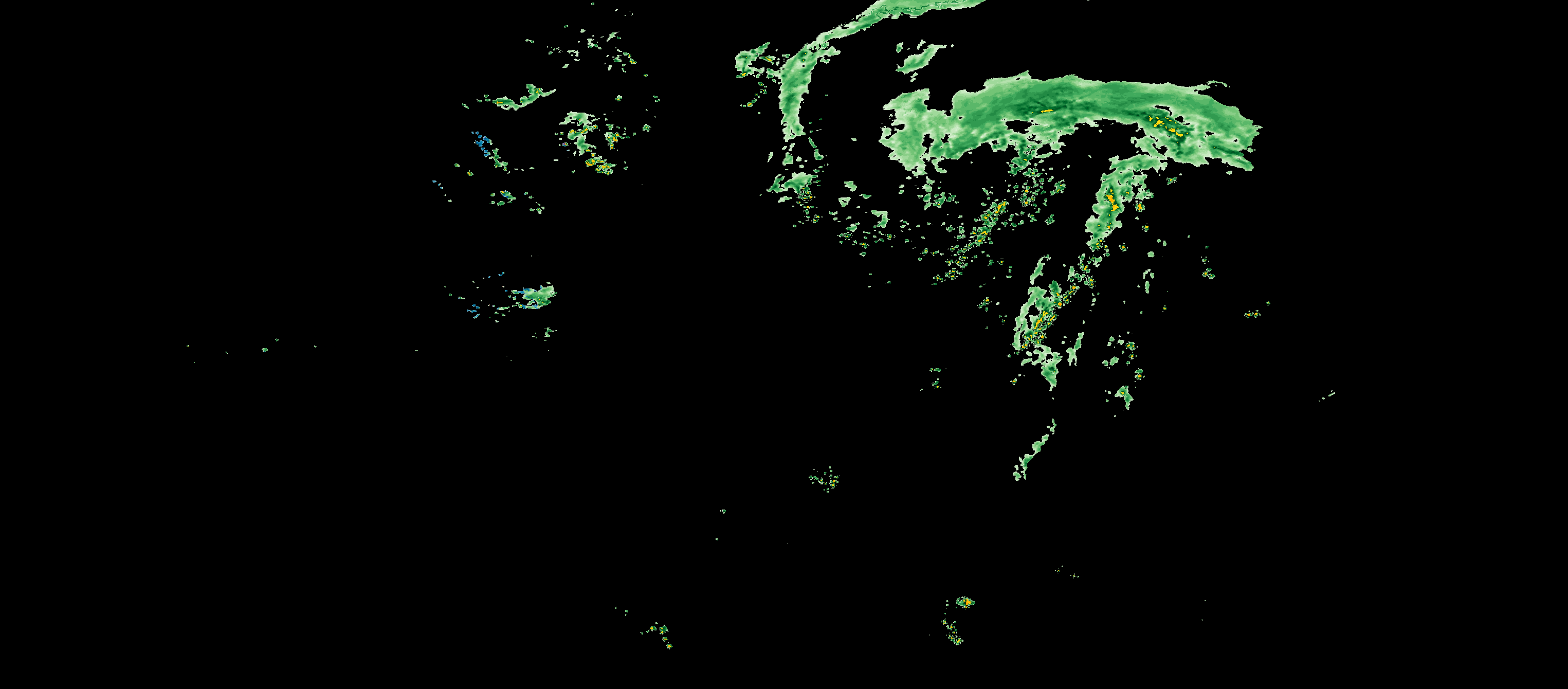
Latest HRRR 1 Hour Forecast with Precipitation Type (
REFP)
Since 2003, the IEM has been providing GIS web services providing NEXRAD composite and single site products. A common feature request made is for forecasted reflectivity to be made as well. Thanks to some simulated reflectivity products from the NCEP HRRR Model, this is now possible.
Quick Overview
- Archive Begins: 14 Jul 2017 00 UTC
- Imagery Resolution: 0.02x0.02 degree lat/lon
- Current raw RASTERs: here, JSON metadata files are available for each file there
- Archived raw RASTERs: here based on UTC timestamps
Changelog
- 25 Nov 2024: Initial support for HRRR Reflectivity with a precipitation type color ramp applied. The hope is to backfill the archive with this eventually.
Tile Map Service (TMS)
You can call the TMS with either model initialization time explicit set or latest run
processed by the IEM. For the explicit time set, the URL form looks like so:
https://mesonet.agron.iastate.edu/cache/tile.py/1.0.0/hrrr::REFD-F0000-201707140100/6/15/24.png
https://mesonet.agron.iastate.edu/cache/tile.py/1.0.0/hrrr::REFP-F0000-201707140100/6/15/24.png
The important parts here are hrrr::REFD-F0000-201707140100 which equates to HRRR model reflectivity
for forecast minute 0000 (needs to be 4 characters) for model initialization on 14 July 2017
at 01 UTC. Whew, that's a mouthful! HRRR forecasts are available every 15 minutes between initialization
and forecast hour 18. Again, this F**** value is in minutes, not hours!
You can also specify 0 as the model initialization time, of which the last run processed by the
IEM will be picked. For example:
https://mesonet.agron.iastate.edu/cache/tile.py/1.0.0/hrrr::REFD-F0000-0/6/15/24.png
https://mesonet.agron.iastate.edu/cache/tile.py/1.0.0/hrrr::REFP-F0000-0/6/15/24.png
Suggested TMS Usage for Realtime
To avoid any caching ugliness on the IEM's end, it is always best to use the explicit TMS URLs
that specify the HRRR model initialization time. A simple query you can do to figure out the
latest run is to fetch the 18-hour (1080 minute) forecast JSON metadata file:
/data/gis/images/4326/hrrr/refd_1080.json
The model_init_utc value in that file would be the latest run available.
Web Map Service (WMS)
There is also a standard WMS located at:
https://mesonet.agron.iastate.edu/cgi-bin/wms/hrrr/refd.cgi
The individual forecast hours have individual LAYERS defined like so
refd_0000 where 0000 is the forecast time in minutes
https://mesonet.agron.iastate.edu/cgi-bin/wms/hrrr/refp.cgi
The individual forecast hours have individual LAYERS defined like so
refp_0000 where 0000 is the forecast time in minutes
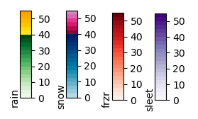
Here's a legend for the REFP product:
FAQ
- How soon is the latest run made available?
At :40 minutes after the hour, a process starts that looks for the HRRR run initialized for the previous hour. This processing takes about 10 minutes, so at for example 01:50 UTC, the 00 UTC run should be available. - What color index to reflectivity value scale is used for the
REFDRASTERS?
These images should match the IEM N0Q Composites. - What color index to reflectivity value scale is used for the
REFPRASTERS?
These images use a 22-color per precipitation type scale. This RASTER is not intended to be used as data within a GIS. - What exact dataset is being shown here?
This is the production NCEP HRRR "REFD" variable, "1000 m above ground" simulated RADAR reflectivity. TheREFPapplies a color ramp to the reflectivity to indicate if it is rain, snow, freezing rain, and finally ice. - Am I free to use this service for lucrative commercial interests?
You betcha, but don't sue us and also send us feedback on how things can be improved for better usage.