Past IEM Features tagged: winter1112
The IEM generates per winter storm analyses of snowfall reports over Iowa and tags them by the winter season. Here are the tags used for the previous winter seasons that these maps are available for:
- Winter 2010-2011
- Winter 2011-2012
- Winter 2012-2013
- Winter 2013-2014
- Winter 2014-2015
- Winter 2015-2016
- Winter 2016-2017
- Winter 2017-2018
- Winter 2018-2019
- Winter 2019-2020
- Winter 2020-2021
- Winter 2021-2022
- Winter 2022-2023
- Winter 2023-2024
- Winter 2024-2025
- Winter 2025-2026

'11-'12 Winter Storm #15
05 Mar 2012 07:37 AMOur parade of snow producing storms continued on Sunday with the central portion of the state receiving the heaviest totals upwards of four inches. This snow and the other recent snows will have a difficult time sticking around with much warmer weather expected today and especially on Tuesday. Our next chance of snow comes midweek, but temperatures are expected to remain mild.
Voting:
Good: 6
Bad: 3
Tags: winter1112

'11-'12 Winter Storm #14
03 Mar 2012 07:33 AMA major storm system impacted the eastern US on Friday bringing deadly tornadoes to places to our southeast and heavy snowfall as well. The extreme eastern portion of the state picked up the highest totals of around 4-5 inches as shown by the featured snowfall analysis. This snow was accompanied by a very strong wind making for difficult driving conditions. Our next snow producer arrives on Sunday, but totals are expected to be very light. A big warm up is expected during the early part of next week.
Voting:
Good: 27
Bad: 7
Tags: winter1112

Warm Winter
01 Mar 2012 05:53 AMThe meteorological winter season is now behind us, so it is time to see how warm this winter was compared with previous ones. The featured map presents an IEM computed analysis of simple daily average temperature percentile. Think of it as the percentage of previous years that this year was warmer than. A good portion of the state is shown at 100%, which would make it the warmest winter on record for the location. This is all based on preliminary and unofficial data, so caveat emptor.
Update: I have regenerated the image after an off-by-one bug was found. The area at a record is smaller.
Voting:
Good: 24
Bad: 5
Tags: winter1112

'11-'12 Winter Storm #13
24 Feb 2012 10:37 AMGetting two snow storms this week has certainly helped to make up for lost time this mostly quiet winter season. Snowfall totals were tempered in some locations thanks to having much of the liquid precipitation fall as rain. Some isolated areas in the state were still able to pick up upwards of eight inches of wet and heavy snow.
Voting:
Good: 32
Bad: 12
Tags: winter1112

'11-'12 Winter Storm #12
22 Feb 2012 05:55 AMThe featured map is an IEM produced analysis of snowfall reports from our most recent winter storm system. Most of the precipitation from this system fell as rainfall, but some folks over northern Iowa got upwards of 2-3 inches of wet snow. Our active pattern looks to continue with northern Iowa again looking at the best chances of snowfall.
Voting:
Good: 21
Bad: 3
Tags: winter1112

Snow deficit for almost everyone
17 Feb 2012 05:54 AMThe featured map is an attempt to estimate the departure from average for total snowfall so far this winter season. Practically the entire state is shown below average with a good portion of central Iowa around two feet below average. The forecast has very limited chances of snow and temperatures well above freezing, so we may need to wait till March for winter to possibly return.
Voting:
Good: 35
Bad: 9
Tags: winter1112

'11-'12 Winter Storm #11
14 Feb 2012 09:51 AMAfter a very slow start to winter, our snow producing storms have been coming a bit more frequently with the most recent storm dumping up to 5 inches over northwestern Iowa. The next storm will be here tomorrow with a mix of rain and snow expected.
Voting:
Good: 9
Bad: 1
Tags: winter1112

Snow Hole
07 Feb 2012 05:54 AMThe featured map is an attempt to show the total season snowfall for Iowa. A few areas of the state have missed out on the heavier snowfall events this season with an area to the west and north of Ames barely getting an inch or two in total so far. The forecast for the next week looks rather dry, but colder.
Voting:
Good: 24
Bad: 1
Tags: winter1112
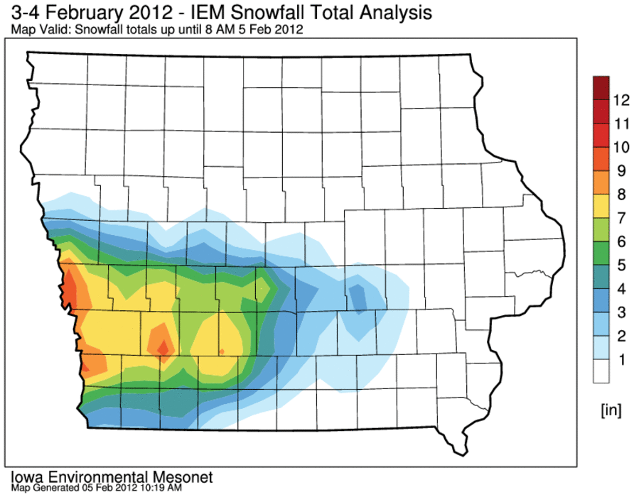
'11-'12 Winter Storm #10
05 Feb 2012 07:45 AMOur most recent bout with a winter storm is now over and the snowfall pattern left over the state is remarkably complex. An intense snow band set up over west-central Iowa and dumped upwards of a foot of very wet snow over isolated areas near Interstate 80. The heaviest totals were west into Nebraska and the same system dumped record snowfalls for February over Denver, Colorado. The featured analysis attempts to show the heaviest snowfall totals and the remarkable gradient on the northern edge of the storm. Northern parts of some counties got just a trace of snow while the southern part got upwards of 8 inches.
Voting:
Good: 13
Bad: 6
Tags: winter1112

One of the warmest winters
31 Jan 2012 06:00 AMYesterday was just another typical day in January for Iowa with high temperature soaring into the lower 60s! The featured chart presents the average temperature accumulated rank by day since 1 December for Ames. We are currently at 5th warmest on record with another month of meteorological winter (1 Dec - 28 Feb) to go. The forecast for this week continues the warm weather with a chance of snow arriving this weekend.
Voting:
Good: 14
Bad: 1
Tags: winter1112

Lack of frozen days
30 Jan 2012 05:54 AMThe featured map presents an IEM analysis of the departure of days below freezing (daily high temperature below freezing) this winter has seen versus previous. Much of the Midwest is shown in the 10 to 25 days below average. The most extreme departures show up in Minnesota and North Dakota. The warm winter continues this week with forecasted temperatures approaching record warm levels today.
Voting:
Good: 20
Bad: 3
Tags: winter1112

'11-'12 Winter Storm #9
28 Jan 2012 09:48 AMThese little snow storms may not be worth the time to document, but they do add to the winter snowfall totals and winter storm counts so might as well! The featured analysis of snowfall reports from our most recent snow generator show amounts mostly at or below an inch. Most of this snow will not stick around long with above freezing temperatures expected this weekend. Some more light snowfall totals are expected this evening across northern Iowa.
Voting:
Good: 7
Bad: 5
Tags: winter1112

Just a taste of winter
25 Jan 2012 05:49 AMOur typical full fledged winter of the past few years has been no where to be found this year. The featured chart presents a time series of hourly air temperature reports along with the daily climatological range. Our coldest period of the year on average is now behind us and the lengthening days start to remind us that spring is not that far away. The near term forecast does not have much winter in store with daily chances of melting snow rather than falling snow.
Voting:
Good: 15
Bad: 0
Tags: winter1112

'11-'12 Winter Storm #8
24 Jan 2012 09:00 AMThe storm system that unfortunately brought deadly tornadoes to the southern US also produced rain, sleet, and snow for Iowa. The featured analysis presents reported snowfall totals, which did not amount to much but created very difficult travel conditions. Our recent stretch of an active winter looks to be settling down some with temperatures back above freezing.
Voting:
Good: 9
Bad: 1
Tags: winter1112

'11-'12 Winter Storm #7
21 Jan 2012 08:39 AMOur most recent winter storm is now in the books with folks in northern Iowa being the lucky ones picking up around 5-8 inches of light and fluffy snow. This storm caused major problems east of us in Chicago as it hit during rush hour on Friday causing most of the city's thoroughfares to become parking lots. Our next winter storm arrives tonight with a better chance of freezing rain and snow on Sunday.
Voting:
Good: 16
Bad: 5
Tags: winter1112

'11-'12 Winter Storm #6
18 Jan 2012 07:32 AMAfter a respite from winter, we have had two snow storms in the past week. The most recent storm brought a lot of wind and snowfall totals mostly less than four inches to parts of the state. We have yet to see a massive winter storm hit the state this winter, but the long range forecast models are teasing a big storm for next week. Until then, there are more chances of snow as our weather pattern remains active.
Voting:
Good: 31
Bad: 5
Tags: winter1112

'11-'12 Winter Storm #5
13 Jan 2012 08:04 AMIt has been a while since our last winter storm, but winter has returned dumping the heaviest snowfall totals over eastern Iowa as shown by the featured map. The western half of Iowa missed out as the storm system rapidly intensified while its center was east of the state. There was plenty of wind with this storm system as well making for travel difficulties.
Voting:
Good: 24
Bad: 9
Tags: winter1112

'11-'12 Winter Storm #4
17 Dec 2011 10:53 AMA small snow storm clipped portions of extreme eastern Iowa Friday night and Saturday morning. Snow fall accumulations were under four inches for Iowa. This snow will not stick around long with above freezing temperatures expected this weekend. The big question at the moment is if we will have a white Christmas. The chances do not look good at this point.
Voting:
Good: 18
Bad: 6
Tags: winter1112

'11-'12 Winter Storm #3
11 Dec 2011 06:39 PMWhile it wasn't much of a winter storm, our most recent bout with winter brought a few inches of snow over portions of southern Iowa. This snow is already gone thanks to warm temperatures on Sunday. More storms are in the forecast for this week, but the chances for rain seem to be better than snow at this point. Some portions of Iowa may set monthly precipitation records for December after this week is over.
Voting:
Good: 7
Bad: 2
Tags: winter1112

'11-'12 Winter Storm #2
04 Dec 2011 11:05 AMOur second significant winter storm of the season is in the books with snowfall totals upwards of six inches reported. A good portion of the state that didn't see snowfall, saw needed heavy rainfall of around an inch. Unlike the nice warm up that occurred after our first winter storm, very cold air is coming with highs expected below freezing for most of the week.
Voting:
Good: 21
Bad: 4
Tags: winter1112

Winter Storm #1
10 Nov 2011 05:33 AMThe first winter storm of the season is in the books dumping very wet snow over swath of Iowa including most of Des Moines. The featured map is a crude analysis of snowfall reports from the storm with the highest totals around 6 inches. We'll produce maps like this after every storm this winter season and you can find these maps later by clicking on "Winter Storms of 2011-2012" link underneath "Most Popular Links" on the homepage. Last year, we had 16 such maps, so we have plenty of winter to go this year!
Voting:
Good: 12
Bad: 1
Tags: winter1112