Past IEM Features tagged: 2014
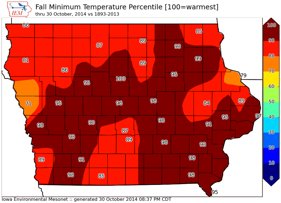
Warm Fall Minimums
31 Oct 2014 06:55 AMUp until today, the minimum fall temperature so far has been rather warm. The featured map displays the percentile rank that this year's fall minimum compares with the long term climate sites in Iowa. For much of the state, the percentile rank is 90 and higher. Low temperatures this morning are well below freezing for most of the state as it appears the first wide spread killing frost has come to Iowa.
Voting:
Good: 22
Bad: 15
Abstain: 8
Tags: 2014
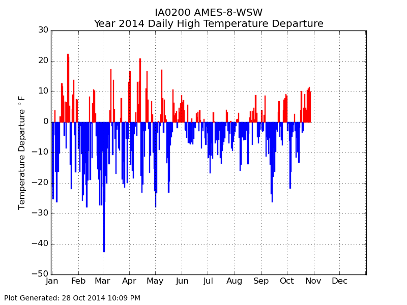
2014 Daily Departures
29 Oct 2014 05:41 AMUp until yesterday, our recent stretch of weather has seen plenty of days with above average high temperatures. The featured chart displays the daily temperature departures for Ames this year. The red bars are days warmer than average and blue bars would be cooler than average. There have been plenty more days below average this year and particularly over this summer. The forecast for the rest of this week has mostly below average weather.
Voting:
Good: 9
Bad: 8
Abstain: 5
Tags: 2014
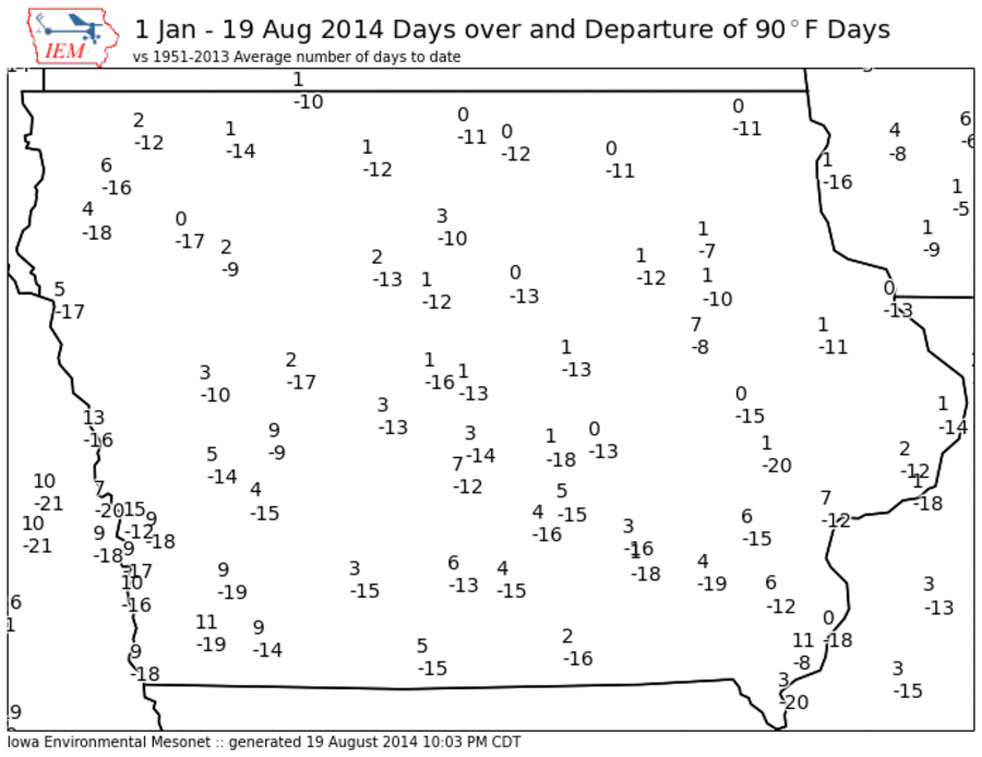
Lack of 90+ Days
20 Aug 2014 05:40 AMGetting really hot summer weather continues to be a struggle for much of the Midwest this year. Even getting days above 90 degrees are few and far between as shown by the featured map. Two values are shown for each of the primary automated weather stations in the state with the top value being the number of days at or above 90 and the bottom value being the departure from long term average for number of days above 90 (year to date). There are still a number of places in the state that have yet to reach this level of warmth. The forecast does hold some hope of reaching this threshold during the next few days.
Voting:
Good: 16
Bad: 9
Abstain: 9
Tags: 2014
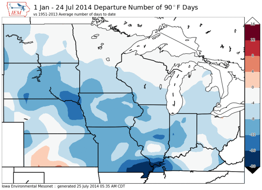
90 Degree Days
25 Jul 2014 05:41 AMThe IEM Daily Feature this week has obsessed over the lack of days this year with a high temperature at or above 90 degrees. This is an arbitrary level picked for no good reason other than it being a number ending in zero. Anyway, the featured map is an attempted analysis at showing the departure this year for number of 90 degree days versus what would be expected. Of course, the numbers are relative as some areas have yet to see any day that warm and only have a small departure shown as they don't typically get as many days as places further south and west do. Only parts of Kansas is shown on this map with positive departures (more 90 degree days than climatology would suggest).
Voting:
Good: 27
Bad: 17
Abstain: 16
Tags: 2014
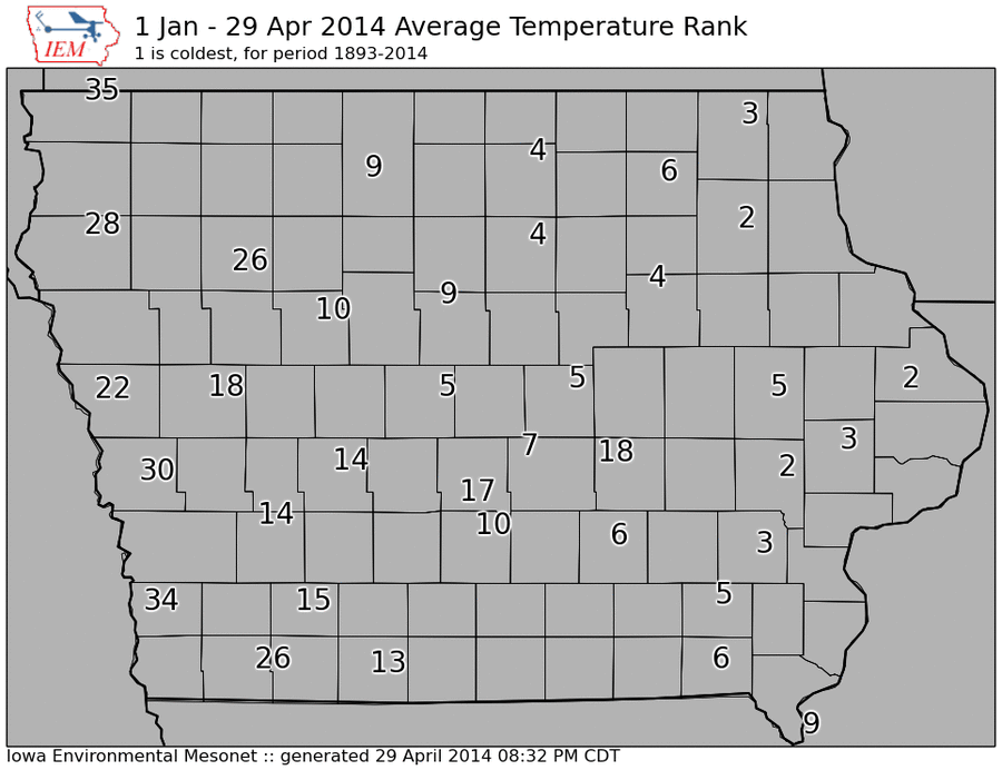
Cold Start to the Year
30 Apr 2014 05:43 AMThe featured map shows IEM computed ranks for how cold the year to date has been so far for 2014. Some locations in eastern Iowa are shown second place, meaning that this year is the second coldest start since 1893. Western Iowa has not been as cold. You may recall the snowfall and storm pattern this winter was much different east to west over the state. This week has seen temperatures struggle in the 40s with another cold day expected today.
Voting:
Good: 33
Bad: 6
Abstain: 4
Tags: 2014
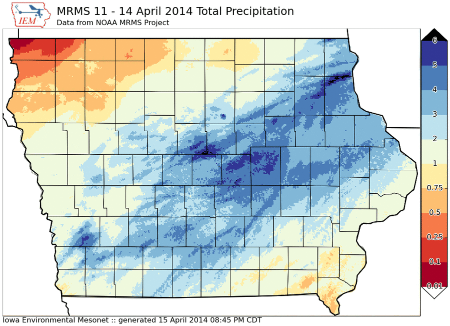
Much Needed April Rain
16 Apr 2014 05:37 AMOn Monday, the IEM Daily Feature was the snowfall from the recent storm. On Tuesday, the feature was the magnitude of the temperature change within 36 hours before snowfall. Today's feature looks at the most important aspect of the most recent major storm system, the significant amount of rainfall over much of the state. The featured analysis is from the NOAA MRMS project, which depicts much of Iowa over an inch with isolated amounts approaching five inches. Thankfully this amount of rainfall fell after the ground had a chance to thaw, so it did not all run off. We could still use more rain to ease the lingering drought from last year.
Voting:
Good: 19
Bad: 3
Abstain: 2
Tags: 2014
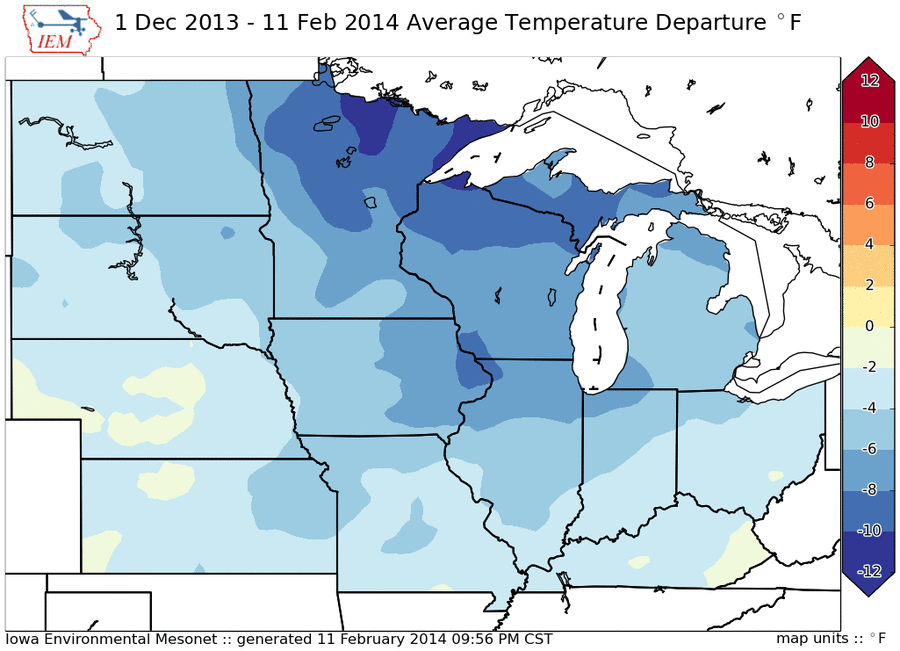
Winter Temperature Departure
12 Feb 2014 05:42 AMThe featured map presents an IEM computed analysis of average temperature departure this winter season. The entire Midwest is indicated below average with the largest negative departures over northern Minnesota and Wisconsin. There is a east / west gradient over Iowa with eastern Iowa having a relatively colder season than western Iowa. The good news is that warmer weather is on the way with temperatures perhaps in the 40s next week!
Voting:
Good: 37
Bad: 4
Abstain: 2
Tags: 2014
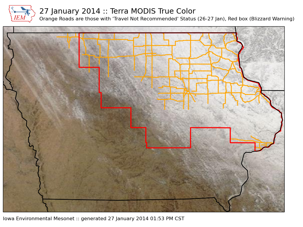
Where there was snow, there was trouble
28 Jan 2014 05:43 AMThe featured map shows the combination of Terra MODIS true-color satellite on Monday, outline of the blizzard warning on Sunday, and roads that were in "travel not advised" status for the recent storm. While the entire state experienced strong winds and bitter cold, areas that actually had snow on the ground experienced the blizzard conditions. Some counties in the blizzard warning had zero travel concerns in the southwestern portion of the county, while the northeastern portion had blizzard conditions. The entire state is once again below zero with very cold wind chills.
Voting:
Good: 37
Bad: 3
Abstain: 6
Tags: blizzard 2014
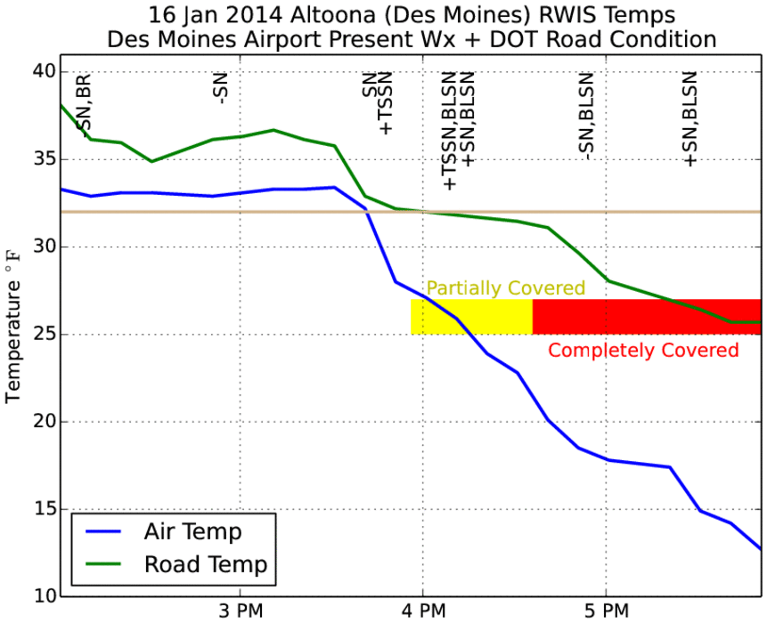
That escalated quickly
18 Jan 2014 05:49 AMThe featured chart is an attempt to explain why only a few inches of snow caused so much trouble for Des Moines on Thursday evening. The green line is the pavement temperature and blue line is the air temperature as observed by the Altoona RWIS site. The text abbreviations at the top are present weather reports from the Des Moines Airport sensor. (SN = snow, TSSN = thunder snow, BLSN = blowing snow, and the plus/minus indicate intensity with + being more intense than -) The colored blocks are the reported road conditions by the DOT for the location. The plot shows that prior to thundersnow report at 4 PM, temperatures were above freezing and the pavement temperatures were close to freezing for 30-45 minutes after the heavy snowfall started while air temperatures plummeted into the teens. So the situation was the initial intense snowfall melted, but soon after froze as air temperatures were way below freezing. The result was a layer of ice that formed on the roadways. The timing was terrible as well with this happening after 4 PM (the start of rush hour traffic). The plot does not show the intense wind speeds, which were creating ground blizzard conditions at the time.
Voting:
Good: 62
Bad: 15
Abstain: 11
Tags: rwis 2014
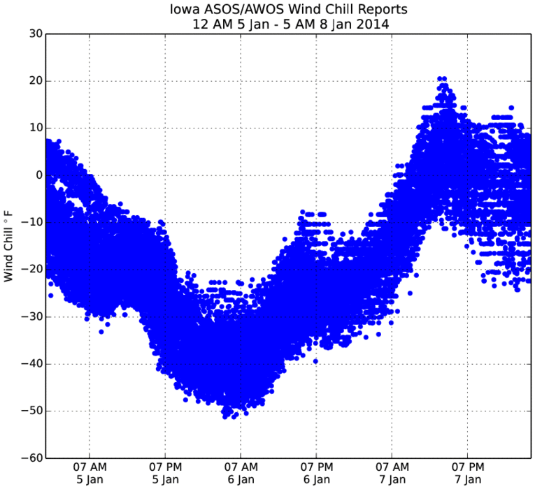
Bone-chilling weather
08 Jan 2014 05:45 AMThe featured chart presents a time series of recent calculated wind chill values from the automated weather stations located at airports in Iowa. While some locations are still quite cold this morning, most values are much warmer than they have been these past two mornings. The chart nicely illustrates that for a stretch on Sunday evening into Monday, the entire state was colder than -20 degrees for wind chill. The forecast has one more night of cold temperatures before moderation occurs and highs expected above freezing!
Voting:
Good: 22
Bad: 5
Abstain: 4
Tags: 2014
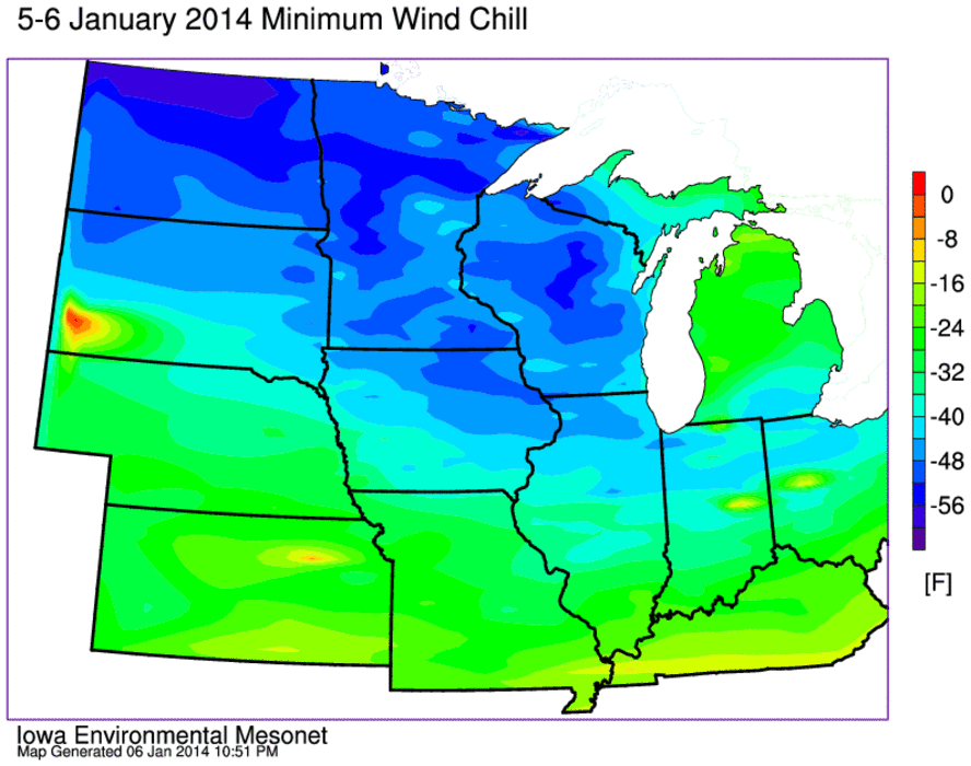
Very cold wind chills
07 Jan 2014 05:44 AMThe featured map presents an IEM computed analysis of minimum calculated wind chill up until 12 AM 7 January. The lowest reading among the airport stations in Iowa was -51 from Oelwein. Most of the state bottomed out in the -35 to -45 range. Some even colder readings were found in Wisconsin, Minnesota, and North Dakota. A few isolated locations were able to reach -60! Temperatures will be on the rebound today with highs above freezing expected by later in the week!
Voting:
Good: 27
Bad: 4
Abstain: 5
Tags: 2014 windchill