Past Features
This page lists out the IEM Daily Features for a month at a time. Features have been posted on most days since February 2002. List all feature titles.
Tue Apr 01, 2014

Front makes fools of us
01 Apr 2014 05:40 AM
Anybody that based their Monday evening attire on the early afternoon temperature were made of fool of as a very strong cold front swept the state dropping the temperature by 40- 50 degrees. The featured chart presents the temperature time series on Monday for seven locations over Iowa. The temperature changes shown are remarkable. Tornadoes were even reported in southwestern Minnesota before the front passed and snow fell later in the evening. Highs today will make it back into the 40s and it appears we'll be stuck in that range for rest of the week.
Voting: Good - 17 Bad - 9
Tags: coldfront
Wed Apr 02, 2014

Tornado Warnings thus far
02 Apr 2014 05:49 AM
The featured chart displays the number of tornado warnings issued by the National Weather Service for the first three months of the year. This year's total is the lowest since 2004. The persistent cold air that has dominated the eastern half of the US is certainly to blame for the lack of tornadoes so far this year. This looks to change this week with tornadoes likely over much of the central US.
Voting: Good - 23 Bad - 2
Thu Apr 03, 2014

First Tornado Warning
03 Apr 2014 05:40 AM
While Iowa got its first tornado of the year last week (brief and weak one near Osceola), we have yet to see a tornado warning. The featured map presents the average date that a NWS office issues their first Tornado Warning of the year. You'll want to click the image for a better view. The general pattern is a progression from south to north as the moisture rich and unstable air from the Gulf of Mexico works its way north. Iowa's tornado season gets started in April. Tornadoes are expected today, but the main threat is to our south.
Voting: Good - 44 Bad - 6
Tags: tornadoes
Fri Apr 04, 2014

'13-'14 Winter Storm #28
04 Apr 2014 08:30 AM
The most recent snow producing storm system is exiting the state this Friday morning with some isolated locations picking up a lot of snowfall. A narrow strip is shown in the featured map analysis over six inches. Having snowfall events like this in early April are common and about what we would expect when large storm systems crank up over the plains. The good news is that any sunshine will make quick work of this snow and the forecast has hope of much warmer temperatures.
Voting: Good - 38 Bad - 10
Tags: winter1314
Mon Apr 07, 2014

Last Snowfall Frequency
07 Apr 2014 05:36 AM
We are finishing our first week of April and the near term forecast holds hope that we won't see any snowfall. Climatology of the last measurable snowfall of the winter/spring season is presented in the featured chart. For today, we are at about 50% frequency. This means that half of the years experienced a measurable snowfall after today's date. A simple assumption would place Des Moines odds at 50/50 of seeing another snowfall this spring. You probably recall picking up snowfall in early May last year! We really do not wish to repeat that this year.
Voting: Good - 24 Bad - 5
Tags: snow
Tue Apr 08, 2014

Morning and Afternoon Showers
08 Apr 2014 05:38 AM
Monday certainly felt more like spring with some passing showers in the morning and some afternoon convective showers with cumulus clouds. The featured chart displays a five minute interval time series of approximate areal coverage of 10+ dBZ RADAR reflectivity. The two peaks are clearly shown with the morning showers due to a passing storm system and the afternoon showers thanks to the heating of the day driving convection. The peak for the afternoon showers was just before 5 PM, which is about the time the lower atmosphere starts to stabilize as the sun reaches a low altitude in the sky (less effective at heating the ground).
Voting: Good - 17 Bad - 4
Tags: instability
Wed Apr 09, 2014

First 70
09 Apr 2014 05:39 AM
Today is the long anticipated day of very warm weather with highs expected into the 70s for much of the state. The featured map presents an analysis of the average first date of 70+ degrees each year and those locations that have already hit that level this year denoted with a x. The eastern half of the map is where the persistent cold and heavy snowfall has occurred this year and you can see how far behind they are with hitting their first 70, by about two weeks. Hitting 70 today would be about normal for areas in the teal color. Minneapolis would be one such area.
Voting: Good - 30 Bad - 4
Tags: 70
Thu Apr 10, 2014

April Wind + Temps
10 Apr 2014 05:38 AM
Temperatures warmed nicely on Wednesday thanks to a dry atmosphere and plenty of wind helping to mix warmer air. The featured chart compares the combination of 3 PM air temperature departure from long term average at 3 PM and the wind speed reported. The shaded areas represent relative frequency with the darkest shades being the most frequent. A simple fit of the data is provided by the red line and yesterday's value is indicated by the brown dot. The chart illustrates that as temperatures get more extreme in the cold or warm direction, wind speeds increase. Of course, correlation is not causation, but there are interconnected physical processes that drive temperatures and wind.
Voting: Good - 14 Bad - 6
Tags: april
Fri Apr 11, 2014

Feeling like May
11 Apr 2014 05:38 AM
The past few days have been a welcome relief from the long stretch of cold and snow this past winter season. The featured chart presents the daily high temperatures this year in relation to when that temperature matches a day's climatology. For example, this past Wednesday's high was approximately the average high for the middle of May. So you can compare how far into the future or past the current weather felt like. Days with a high temperature colder than any average high are drawn back to the first of January. Not much relative warmth was to be had in February and March until the very end. The forecast for the next few days continues the warmth with chances of rain.
Voting: Good - 44 Bad - 14
Mon Apr 14, 2014

'13-'14 Winter Storm #29
14 Apr 2014 08:15 AM
The hope that Iowa was done with snow producing storms was dashed Sunday evening as yet another system was able to dump snow on Iowa. The storm system also brought a significant amount of rain with it as well. Snowfall totals were generally less than three inches and will melt quickly with any amount of sunshine. The cool weather looks to stick around this week with further chances of snow later in the week.
Voting: Good - 15 Bad - 4
Tags: winter1314
Tue Apr 15, 2014

From 85 to snow
15 Apr 2014 05:37 AM
After hitting a balmy 85 degrees on Saturday, it was only less than 36 hours later that the Des Moines Airport reported falling snow! The featured graphic shows events where the temperature went from 75+ degrees to then having a snow report within 36 hours. Our most recent event comes in a close third behind 1991 and 1975. There are only ten events on record for Des Moines going from 75+ to snowfall, so this type of dramatic swing is not that common.
Voting: Good - 18 Bad - 9
Tags: snow coldfront
Wed Apr 16, 2014
Much Needed April Rain
16 Apr 2014 05:37 AM
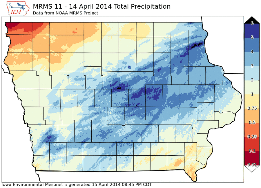
On Monday, the IEM Daily Feature was the snowfall from the recent storm. On Tuesday, the feature was the magnitude of the temperature change within 36 hours before snowfall. Today's feature looks at the most important aspect of the most recent major storm system, the significant amount of rainfall over much of the state. The featured analysis is from the NOAA MRMS project, which depicts much of Iowa over an inch with isolated amounts approaching five inches. Thankfully this amount of rainfall fell after the ground had a chance to thaw, so it did not all run off. We could still use more rain to ease the lingering drought from last year.
Voting: Good - 19 Bad - 3
Tags: 2014
Generate This Chart on Website
16 Apr 2014 05:37 AM
On Monday, the IEM Daily Feature was the snowfall from the recent storm. On Tuesday, the feature was the magnitude of the temperature change within 36 hours before snowfall. Today's feature looks at the most important aspect of the most recent major storm system, the significant amount of rainfall over much of the state. The featured analysis is from the NOAA MRMS project, which depicts much of Iowa over an inch with isolated amounts approaching five inches. Thankfully this amount of rainfall fell after the ground had a chance to thaw, so it did not all run off. We could still use more rain to ease the lingering drought from last year.
Voting: Good - 19 Bad - 3
Tags: 2014
Generate This Chart on Website
Thu Apr 17, 2014
Pressure Change
17 Apr 2014 05:36 AM
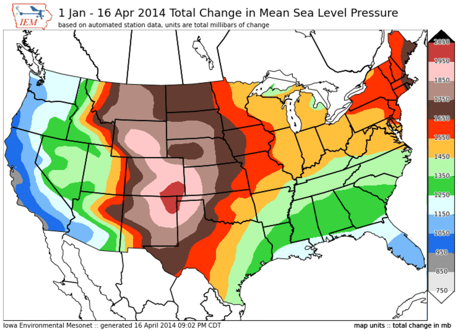
Are you old like me and do not enjoy it when the pressure changes as various parts of the body start to ache? The featured map displays the total amount of pressure change for the year to date. This value represents the amount the mean sea level pressure observation has changed hour to hour for the year. The largest values (most change) are in southeastern Colorado / northeastern New Mexico while the lowest values (least change) are along the coast in southern California. The maximum area is the preferred location for low pressure systems to develop thanks to geography and the jet stream. If you are bothered by pressure changes, you may wish to move to Florida or the coast of California!
Voting: Good - 21 Bad - 6
Tags: mslp pressure
17 Apr 2014 05:36 AM
Are you old like me and do not enjoy it when the pressure changes as various parts of the body start to ache? The featured map displays the total amount of pressure change for the year to date. This value represents the amount the mean sea level pressure observation has changed hour to hour for the year. The largest values (most change) are in southeastern Colorado / northeastern New Mexico while the lowest values (least change) are along the coast in southern California. The maximum area is the preferred location for low pressure systems to develop thanks to geography and the jet stream. If you are bothered by pressure changes, you may wish to move to Florida or the coast of California!
Voting: Good - 21 Bad - 6
Tags: mslp pressure
Fri Apr 18, 2014

Seven Sundays of Rain?
18 Apr 2014 05:37 AM
A saying in weather folklore is that if it rains on Easter Sunday, it will rain for the next seven Sundays after. With rain forecasted this Sunday, the featured chart investigates if this saying is true. The two series of values show the frequency of measurable precipitation after an Easter Sunday with rain and for all Easter Sundays. You can see that the frequencies for precipitation after an Easter with precipitation are no higher than for all cases and they are much less than 50%. Three years had five out of the seven Sundays with precipitation after a wet Easter. Those were 1883, 1884, and 1961.
Voting: Good - 38 Bad - 18
Tags: folklore easter
Mon Apr 21, 2014

Warm Easter
21 Apr 2014 05:35 AM
Temperatures on Easter Sunday warmed into the 80s for much of the state. Only extreme northeastern Iowa was left in the 60s with clouds and some rain. For Des Moines, it was one of the warmer Easter Sunday's on record as shown by the featured chart. Only 1987 at 86, 1977 at 85, and 1908 at 84 tied or beat the 84 reported by the Des Moines Airport sensor on Sunday. Keep in mind that Easter falls on a wide range of dates in the spring, so some years are mid April and others are in March! High temperatures this week will be closer to average and back in the 60s.
Voting: Good - 17 Bad - 6
Tags: easter
Tue Apr 22, 2014
Slow Corn Progress
22 Apr 2014 05:36 AM
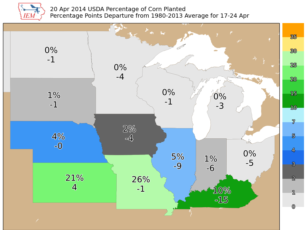
The USDA released their weekly crop progress report on Monday summarizing activity till 20 April. The featured map displays the statewide corn planting progress estimates along with the departure from average. Cold temperatures and cold soil temperatures have caused the delay in Iowa, but we are still only a few percentage points behind average. The largest departures are over the eastern half of the corn belt where the winter was the most abnormally extreme.
Voting: Good - 26 Bad - 4
22 Apr 2014 05:36 AM
The USDA released their weekly crop progress report on Monday summarizing activity till 20 April. The featured map displays the statewide corn planting progress estimates along with the departure from average. Cold temperatures and cold soil temperatures have caused the delay in Iowa, but we are still only a few percentage points behind average. The largest departures are over the eastern half of the corn belt where the winter was the most abnormally extreme.
Voting: Good - 26 Bad - 4
Wed Apr 23, 2014

SPC Watches
23 Apr 2014 05:36 AM
The Storm Prediction Center issues Tornado and Severe Thunderstorm watches. The featured chart displays the number of watches issued for the year to date period since 1997 and the percentage of total watches that have some coverage over Iowa. It has been rather quiet for severe weather activity nationwide, but that looks to change starting today with a number of rounds of severe weather expected over the coming days.
Voting: Good - 15 Bad - 5
Tags: spc
Generate This Chart on Website
Thu Apr 24, 2014

Seasonal Precipitation
24 Apr 2014 05:37 AM
Needed rainfall is currently falling over Iowa. This rainfall is needed due to the deficits that built up during the later part of the growing season in 2013. The featured chart presents the seasonal precipitation totals by year and a simple trailing 30 year moving average plotted as well. The recent few years have seen very dry conditions for the Jul-Aug-Sep period, but they have been compensated by wet springs. The complications with a wet spring are delays and difficulties with planting the agricultural crops.
Voting: Good - 19 Bad - 4
Tags: precip climate
Fri Apr 25, 2014

MOS Forecasts
25 Apr 2014 05:35 AM
Model Output Statistics (MOS) are point forecasts produced from combining raw numerical model output and statistics on past model performance. Over time as subsequent MOS forecasts are produced, these forecasts create a range of predicted values. The featured chart shows the range of the combined MOS forecasts over time and the actual observations from the Des Moines Airport. The MOS forecast range from the NAM model has missed the high temperature for the past two days and seven out of the past nine days. Even with this seemingly inaccuracy, the forecast for April 22 was very precise over time and accurate! Models are not perfect, so there is still plenty of room for humans to add value.
Voting: Good - 48 Bad - 16
Tags: mos
Generate This Chart on Website
Mon Apr 28, 2014

April Precipitation So Far
28 Apr 2014 05:38 AM
The featured map is a high resolution estimate of precipitation for April from the NOAA MRMS project. This map is valid up until 12 AM this Monday morning (28 April). While some parts of the state are shown approaching 10 inches for the month, others have struggled in the two to four inch range. More rain is expected this week and can hopefully even out some of the differences found with the totals so far!
Voting: Good - 19 Bad - 5
Tue Apr 29, 2014

Severe April Event
29 Apr 2014 05:45 AM
Almost three years to the date of the major severe weather outbreak of 27 April 2011, another significant event is ongoing. The featured image presents the number of active severe thunderstorm and tornado warnings by minute since midnight on the 27th. Monday evening saw a large number of tornado warnings issued with a peak of 14 tornado warnings valid at one time over the United States. Iowa missed out on the event on Monday and will miss out on today's as well. This is all thanks to a very large storm complex that will keep us in the clouds and rain for much of the rest of this week.
Voting: Good - 20 Bad - 4
Wed Apr 30, 2014
Cold Start to the Year
30 Apr 2014 05:43 AM
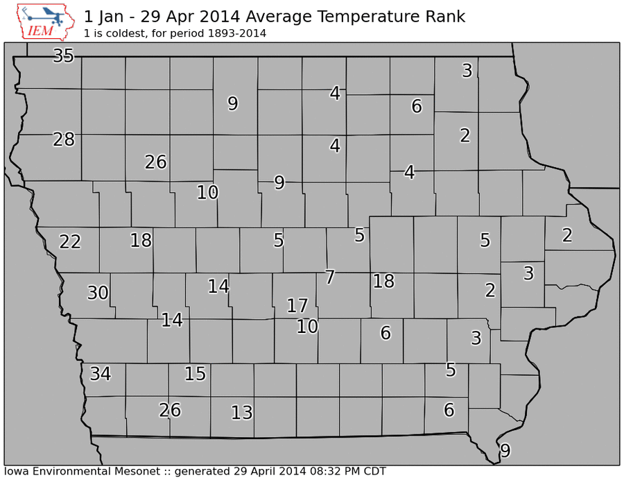
The featured map shows IEM computed ranks for how cold the year to date has been so far for 2014. Some locations in eastern Iowa are shown second place, meaning that this year is the second coldest start since 1893. Western Iowa has not been as cold. You may recall the snowfall and storm pattern this winter was much different east to west over the state. This week has seen temperatures struggle in the 40s with another cold day expected today.
Voting: Good - 33 Bad - 6
Tags: 2014
30 Apr 2014 05:43 AM
The featured map shows IEM computed ranks for how cold the year to date has been so far for 2014. Some locations in eastern Iowa are shown second place, meaning that this year is the second coldest start since 1893. Western Iowa has not been as cold. You may recall the snowfall and storm pattern this winter was much different east to west over the state. This week has seen temperatures struggle in the 40s with another cold day expected today.
Voting: Good - 33 Bad - 6
Tags: 2014