Past Features
This page lists out the IEM Daily Features for a month at a time. Features have been posted on most days since February 2002. List all feature titles.
Sun Feb 02, 2014

'13-'14 Winter Storm #16
02 Feb 2014 09:34 PM
The featured map presents an analysis of snowfall totals from our most recent snow producing winter storm system. Technically the snowfall for this analysis came in two waves on Friday and then again on Saturday. Much of the state got at least an inch or two with the highest amounts over far southeastern Iowa. Our next snow storm arrives late Monday with the heaviest totals expected over southern Iowa. Very cold temperatures look to be in the forecast this week as well. Winter continues to roll on!
Voting: Good - 22 Bad - 6
Tags: winter1314
Tue Feb 04, 2014

Winter Storm Warnings
04 Feb 2014 05:45 AM
The NWS has a Winter Storm Warning in effect for much of southern Iowa from today into Wednesday morning. The featured map presents the total number of Winter Storm Warnings issued by the NWS since late 2005. Northeastern Iowa has the largest totals in the state with the largest total (130) in the country for Flattops forecast zone in Colorado. Winter Storm Warnings are typically issued for significant snowfall accumulations over a twelve or more hour period. Our snowfalls so far this winter have not been excessive, so the number of warnings issued has been lower than recent average.
Voting: Good - 61 Bad - 16
Tags: nws winter
Wed Feb 05, 2014

'13-'14 Winter Storm #17
05 Feb 2014 09:10 AM
And yet another winter storm system brings snowfall to the state! Unlike many of the previous storm systems, this one was a more traditional winter storm that traversed from west to east passing just to our south. These type of systems have more moisture to work with than clipper type systems and snowfall totals, accordingly, were higher than we have recently seen. Three to Five inches were common over much of southern Iowa with higher totals exceeding seven inches. Bitterly cold air is once again back in Iowa with lows tonight well below zero.
Voting: Good - 42 Bad - 12
Tags: winter1314
Thu Feb 06, 2014

Wind Chill Advisories/Warnings
06 Feb 2014 06:06 AM
The entire state is under a wind chill advisory this morning with current readings in -30 to -20 range. The featured chart presents a time series of calculated wind chill values for Waterloo since 20 Dec 2013. The shaded regions are the wind chill advisories and warnings issued by the National Weather Service. There have been plenty of these events so far this winter season and only a modest break between then during the second week of January. A brief warm-up back to values closer to freezing is expected tomorrow before the next round of snow and cold pushes us back into deep freeze weather.
Voting: Good - 35 Bad - 8
Tags: windchill
Fri Feb 07, 2014

Non-Normal Roads
07 Feb 2014 05:42 AM
The parade of snow producing storms and blowing snow conditions have made travel a bit difficult in Iowa this winter season. The featured map displays the frequency this year that a road segment was reported to be in a non-normal condition. The highest frequencies are shown in the Dubuque area with much lower values in western Iowa. The next winter storm system arrives tonight and is expected to dump a few inches of snow on the state for Saturday. Temperatures look to remain very cold for the next week.
Voting: Good - 74 Bad - 18
Tags: roads
Mon Feb 10, 2014

'13-'14 Winter Storm #18
10 Feb 2014 05:41 AM
And yet another snow producing winter storm brought 1-3 inches over a good portion of Iowa. This event did not include significant winds, so impacts were on the minimal side. The largest totals were over far eastern Iowa. Temperatures are once again very cold this Monday morning, but there is hope in the forecast as temperatures above freezing are expected later this week!
Voting: Good - 32 Bad - 8
Tags: winter1314
Tue Feb 11, 2014

Sub-Zero Hours
11 Feb 2014 05:42 AM
Temperatures are once again well below zero for much of the state this morning. We have been below zero for much of this winter season as shown by the featured chart for Dubuque. For the site, this year's total amount of time below zero is only surpassed by the winter of 1962-1963. Other locations in the state are still behind the epic winters of the late 1970s. The good news is that the forecast continues to hint at warmer weather next week with highs back above freezing!
Voting: Good - 30 Bad - 3
Tags: subzero
Wed Feb 12, 2014
Winter Temperature Departure
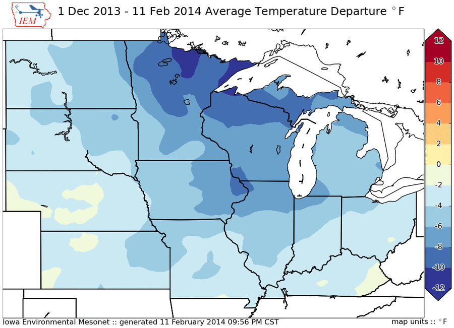
12 Feb 2014 05:42 AM
The featured map presents an IEM computed analysis of average temperature departure this winter season. The entire Midwest is indicated below average with the largest negative departures over northern Minnesota and Wisconsin. There is a east / west gradient over Iowa with eastern Iowa having a relatively colder season than western Iowa. The good news is that warmer weather is on the way with temperatures perhaps in the 40s next week!
Voting: Good - 37 Bad - 4
Tags: 2014
Generate This Chart on Website
Thu Feb 13, 2014

Hours for Snow
13 Feb 2014 05:47 AM
For rainfall, it is well established that Iowa experiences two peaks in hourly frequency. One is in the early morning hours associated with a phenomena known as the low level jet and the other, in the very late afternoon/evening hours associated with the heating of the day driving storms. For snowfall, the forcing is a bit different and the featured chart presents the hourly frequencies of having snowfall reported by the Des Moines Airport sensor. The peak shown for all events is during the coldest time of day (right before sunrise), which would be the best odds that a precipitating storm could have temperatures cold enough to support snow. That is not the entire story though as the smaller bars depict when the most intense snowfalls are reported (coded +SN in the reports). These intense events have a clear diurnal pattern with the maximum in the late afternoon hours. It is not entirely clear why this is, but a logical explanation is that convective snow (like what we experienced in mid January) is enhanced and perhaps forced by daylight heating. While the bars are normalized, you should notice the large difference in frequency between the intense +SN events and all snow events.
Voting: Good - 32 Bad - 12
Tags: asos snow metar
Fri Feb 14, 2014

Deep Freeze
14 Feb 2014 05:40 AM
A significant impact of the cold winter season has been an increase in underground water line breaks. These occur when freezing temperatures reach the depth that water pipes are buried. The featured chart displays a time series of average daily subsurface temperatures from the Tipton DOT RWIS site. This site has a probe taking a profile temperature down to 70 inches deep at a six inch interval. Sub-freezing temperatures are indicated down to five feet! The caveat with these readings is that the profile is below a pavement surface, which tends to have more sand / rock than soil. This permits more rapid cooling than underneath a grassy surface. The plot nicely depicts the temporal lag it takes for heat to be lost and temperatures cool, the further down the profile you go.
Voting: Good - 45 Bad - 6
Tags: rwis frost
Sat Feb 15, 2014

'13-'14 Winter Storm #19
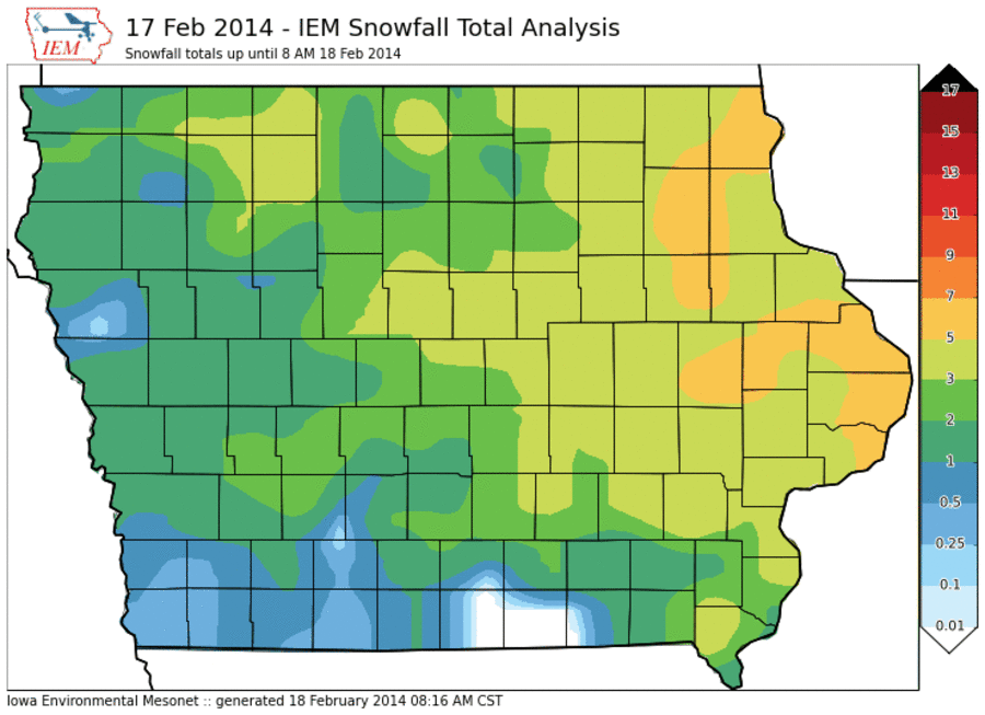
15 Feb 2014 04:10 PM
The snow producing winter storms are coming faster than I can post daily features on their snowfall totals! The featured map is an analysis of reports from the snowfall on Friday. Some of the snow from Saturday's storm may have been included in this analysis. Totals were generally less than four inches, but higher amounts were observed over southeastern Iowa. There was some wind with this snow as well, so driving conditions were once again difficult.
Voting: Good - 36 Bad - 3
Tags: winter1314
Sun Feb 16, 2014

'13-'14 Winter Storm #20
16 Feb 2014 09:10 PM
And yet another snow producing winter storm this season quickly dumped a couple of inches or so on Iowa this past Saturday. The featured analysis combines NWS Cooperative, NWS Local Storm, and CoCoRaHS reports. Totals approached four inches and were generally in the 1-3 inch range. Monday is another day, so that means another snow producing storm! The heaviest totals will be over northeastern Iowa this time. The good news is that temperatures will be warmer this week with highs above freezing!
Voting: Good - 35 Bad - 8
Tags: winter1314
Tue Feb 18, 2014
'13-'14 Winter Storm #21
18 Feb 2014 08:19 AM
Iowa experienced yet another snow producing storm on Monday with totals upwards of six inches over portions of eastern Iowa. The snow came quickly with rates approaching three inches per hour and thundersnow was reported as well. The good news is that temperatures are quickly warmed and will eat away at the snow cover of the state. The bad news it that a blizzard watch is in effect for Thursday as the next winter storm system looks to be a very powerful.
Voting: Good - 27 Bad - 2
Tags: winter1314
Wed Feb 19, 2014

Snow Cover and Highs
19 Feb 2014 05:41 AM
Tuesday was a welcome relief from winter with nearly the entire state reaching 40+ degrees for a high temperature. The feature chart presents the afternoon high temperature vs the reported snow cover depth yesterday morning. This comparison is made between a grid analysis of both observed variables. The relationship is clear with areas with the least amount of snow having the warmest temperatures. The snow free areas in western Iowa were able to reach the 60s! Our winter relief will not last long as Iowa gears up for an expected blizzard on Thursday.
Voting: Good - 25 Bad - 5
Tags: snowcover
Thu Feb 20, 2014

Blizzard Warnings
20 Feb 2014 05:16 AM
Blizzard warnings are active for today as a major winter storm strengthens over the plains. The featured map presents the number of NWS issued Blizzard Warnings since late 2005. You'll want to click the image for a better view. Blizzard conditions are not trivial to produce as the combination of near zero visibility needs to coincide with snow and very strong winds. The map shows the favored area for these conditions over very flat and mostly tree- less Upper Midwest. The gradient is clear in Minnesota as trees slow surface winds down and help keep blowing snow in check.
Voting: Good - 47 Bad - 6
Tags: nws blizzard
Fri Feb 21, 2014

'13-'14 Winter Storm #22
21 Feb 2014 08:11 AM
Most of our winter storm systems this season have been on the weak side with limited moisture to work with. Thursday's storm was much more powerful and had plenty of moisture to work with. Besides the significant snowfall totals dumped over northcentral Iowa, this system also brought rain and measurable accumulations of sleet / small hail. Winds increased Thursday evening creating blizzard conditions over northern Iowa, but impacts were a bit lower than feared due to sightly above freezing temperatures that lowered snowfall totals (due to very high water content), which also helped to decrease the ability of the snow to blow around. The situation over northcentral Iowa is a mess this morning.
Voting: Good - 49 Bad - 7
Tags: winter1314
Sat Feb 22, 2014

Svr/Tor Warning during Blizzard Warning
22 Feb 2014 09:22 AM
The recent blizzard event on Thursday featured a somewhat rare combination of a forecast zone being under a blizzard warning and also having a severe thunderstorm warning active at the same time! The featured chart presents an IEM computation of the number of times this has happened since late 2005. This combination happens approximately once each year for some lucky location in the country.
Voting: Good - 31 Bad - 6
Tags: nws blizzard
Mon Feb 24, 2014

West-East Snow Gradient
24 Feb 2014 05:39 AM
The featured map presents NWS reported snowfall totals for this cold season. A remarkable gradient exists over Iowa with extreme eastern Iowa over 50 inches and extreme western Iowa around 10-15. A similar gradients exists over Minnesota as snow producing storms have favored the eastern portion of the upper MidWest. Some snowfall is expected today with the largest totals over western Iowa, but amounts will only be a couple of inches.
Voting: Good - 42 Bad - 7
Tags: winter1314
Tue Feb 25, 2014

'13-'14 Winter Storm #23
25 Feb 2014 01:42 PM
After featuring the west to east gradient of snowfall so far this winter season with western Iowa totals much less than eastern Iowa, the heaviest totals were over western Iowa for this most recent storm. The totals were not that impressive though with most locations less than three inches. The bad news is very cold air is once again here for the rest of this week as winter rolls on.
Voting: Good - 14 Bad - 5
Tags: winter1314
Wed Feb 26, 2014

Snow Inequity
26 Feb 2014 05:33 AM
Monday's IEM Daily Feature showed a remarkable gradient in this season's snowfall total with eastern Iowa around 50 inches and western Iowa around 15. The featured chart compares the seasonal snowfall totals for Dubuque (eastern) vs Le Mars (western). This year has seen a remarkable difference, but there is still plenty of winter season left. Years on the extremes are labelled with a number of the labelled points being extremely cold winters as this one.
Voting: Good - 39 Bad - 5
Tags: snow
Thu Feb 27, 2014

Time below 0
27 Feb 2014 05:39 AM
Temperatures are, once again, below zero for much of the state this morning. The featured map presents the amount of time this winter season a location has experienced a sub zero temperature. The amount of time is expressed in units of 24 hour days, not the number of days with a sub zero temperature. If you are curious how these numbers compare to what we typically experience during winter, they are about 1.5 to 3 times larger than average. It is interesting to compare Iowa's totals with those further north of us. It has certainly been bad in Iowa, but it can be so much worse!
Voting: Good - 41 Bad - 3
Tags: subzero
Fri Feb 28, 2014

Relative Time below 0
28 Feb 2014 05:36 AM
Yesterday's feature presented the number of hours below zero Fahrenheit so far this winter season. The icebox in northern Minnesota had much larger totals than anywhere else in the Midwest, but they are also typically cold during the winter season! Today's image attempts to normalize the presented totals by comparing this year's amount of time below zero with the past 41 years worth of data. This analysis places Ohio and SE Michigan with the highest ratios. A ratio of 3 would imply that the location has seen three times as long a duration below zero than on average. So while Minnesota has seen roughly double the sub-zero time (which is a much longer duration in absolute terms than in Ohio), it is the eastern part of the Midwest that has been the most relative difference this winter season.
Voting: Good - 49 Bad - 16
Tags: subzero winter1314