The featured chart presents the maximum period with temperatures below
freezing based on hourly observations for Des Moines. The longest
period this year is only a bit longer than three previous years. There
is still plenty of winter season to go and as is shown by the bottom
chart, there are longest streaks of the season that get started in
February and even March. The forecast has been hinting at a return of
winter to the state with chances of snow, but temperatures do not look
that cold at least to early next week.
Wednesday was yet another amazingly warm day in winter for most folks
in Iowa. Des Moines hit 60 degrees for the third day in a row. The
weather bureau noted that this was the first three day stretch of 60
degrees for Des Moines during the period of 15 Dec to 15 Feb on record!
The featured chart presents the warmest three day streak of weather
based on the minimum high temperature during that period. The first
day of the streak is used to place the three day value for a month.
Our most recent streak would be the warmest for January besting the
previous streak in 2002 of 59.
Winter is expected to return this weekend with a storm system
developing just to our southwest this morning. The weather forecast
models have been teasing a significant snowfall for Iowa, but change
their mind after sequential runs in time. The featured chart presents
Global Forecast System (GFS) model forecasted precipitation for a grid
point near Des Moines. The model is run every six hours producing a
forecast out for the next two weeks or so. Model runs up until January
30th had this weekend being dry. Subsequent model runs then dumped
heavy amounts of rain or snow or some mixture for Des Moines. Two
model runs yesterday had Des Moines missing almost all precipitation.
The most recent run (top row) now has rain today and snow on Saturday.
Model inconsistencies like this make life fun and the folks that
forecast the weather for a living lose hair or grey quickly.
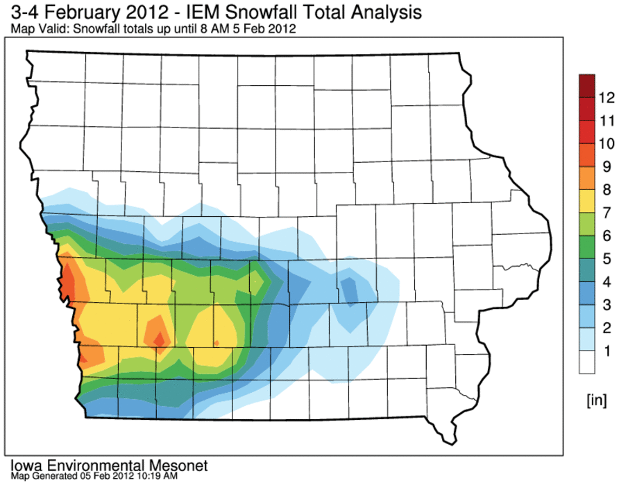
Our most recent bout with a winter storm is now over and the snowfall
pattern left over the state is remarkably complex. An intense snow
band set up over west-central Iowa and dumped upwards of a foot of very
wet snow over isolated areas near Interstate 80. The heaviest totals
were west into Nebraska and the same system dumped record snowfalls for
February over Denver, Colorado. The featured analysis attempts to show
the heaviest snowfall totals and the remarkable gradient on the
northern edge of the storm. Northern parts of some counties got just a
trace of snow while the southern part got upwards of 8 inches.
The featured map is an attempt to show the total season snowfall for
Iowa. A few areas of the state have missed out on the heavier snowfall
events this season with an area to the west and north of Ames barely
getting an inch or two in total so far. The forecast for the next week
looks rather dry, but colder.
The featured chart is another illustration of how warm this winter has
been. The chart shows the number of days this winter season that the
low temperature has been at or below a given temperature threshold.
The blue line represents the minimum total for any year prior to this
year. The teal line is this winter and it closely hugs or exceeds the
previous minimum at some thresholds. The overall minimum temperature
has only been 1 degree this year, which would be the warmest on record
if it stands for the rest of winter. Our last winter is plotted in red
and shows how much different it was than this year.
The featured image is a composite of webcam images from Jefferson Iowa
for the past nine years. The reported snow depth is shown for each
year. There has been very little snowfall to speak of for many places
in the state this winter as compared with recent years. A chance of
snowfall is expected this weekend, but temperatures are expected to
warm again to above freezing to help melt it away.
While not as warm as we recently have been, Thursday was another day
this winter season with the high temperature above average. The
featured chart presents the number of days for this winter period each
year that the high temperature was above average. This year reverses
the trend of the past four years having less than half of the days in
this period below average. Colder air is back today with high
temperatures struggling in the teens for the next two days.
It is always fun to check out satellite imagery on clear sky days in
the winter time. The featured image shows Terra MODIS true color
satellite imagery with high temperatures on Sunday. Having snow cover
on Sunday made the difference between having a high temperature
slightly below freezing to one that was a bit above freezing. Our next
winter storm is here this morning with snowfall totals expected to not
amount to much.
After a very slow start to winter, our snow producing storms have been
coming a bit more frequently with the most recent storm dumping up to 5
inches over northwestern Iowa. The next storm will be here tomorrow
with a mix of rain and snow expected.
The featured chart presents our winter to date rank for average
temperature for Ames. We had gotten to 2nd warmest only to fall back
to 6th place after our recent stretch of more winter like weather. The
forecast does not look to better our ranking, but temperatures are
expected comfortably above freezing each day. Only two more weeks to
go until we are out of meteorological winter!
This winter has certainly seemed more like the other seasons of the
year rather than the brutal winters we remember from past years. The
featured chart is another metric showing how few winter weather
headlines have been issued by the National Weather Service so far this
winter as compared with the past six years. The value shown represents
the average number of winter weather advisories and warnings per county
in Iowa. The values are partitioned each year for before and after 16
Feb periods, so there is still plenty of time for more winter storms.
The featured map is an attempt to estimate the departure from average
for total snowfall so far this winter season. Practically the entire
state is shown below average with a good portion of central Iowa around
two feet below average. The forecast has very limited chances of snow
and temperatures well above freezing, so we may need to wait till March
for winter to possibly return.
This winter certainly has not felt much like recent winters with the
number of days with a high temperature over 40 nearly equaling the
combined total of the past 4 years! Only two yeas in the past (1919 and
2002) have seen more winter to date days at or above 40 than this year.
The forecast has yet more days in the 40s with more chances of rain
than snow.
The featured map presents an estimate of precipitation for the calendar
day on Monday. Most of this fell as rain and provided some much needed
moisture for areas of the state that have been recently dry. An
analysis of snowfall from this storm will be presented tomorrow. Our
next storm system arrives on Wednesday with better chances of rainfall
than snow.
The featured map is an IEM produced analysis of snowfall reports from
our most recent winter storm system. Most of the precipitation from
this system fell as rainfall, but some folks over northern Iowa got
upwards of 2-3 inches of wet snow. Our active pattern looks to
continue with northern Iowa again looking at the best chances of
snowfall.
Ames, Iowa has found a way to mostly avoid each snow storm this winter
with the largest single event snowfall total of just two inches. The
computer models were keeping our next winter storm off to our north,
but have shifted south with the heaviest totals coming dangerously
close to central Iowa. The featured graphic is forecast probabilities
of four inches of snow from the HPC for the 24 hour period ending
Friday morning. In this depiction, Ames is on the southern fringe of
the highest probabilities.
Getting two snow storms this week has certainly helped to make up for
lost time this mostly quiet winter season. Snowfall totals were
tempered in some locations thanks to having much of the liquid
precipitation fall as rain. Some isolated areas in the state were
still able to pick up upwards of eight inches of wet and heavy snow.
A strong wind and warm temperatures over this past weekend made for
quick work of much of the snow that fell last week over Iowa. The
featured image simply shows the difference between late Saturday
morning and Sunday afternoon from the MODIS satellites. Our next storm
system arrives this evening with the heaviest snowfall expected to stay
to our north.
A major winter storm is organizing this morning with the worst
conditions expected to stay just to our north where blizzard warnings
are in effect. Unlike the past two winters where each county in Iowa
got at least one blizzard warning issued for the season, this winter
has seen none thus far.
Leap day presents an interesting aspect of climatology. In some cases,
the date is ignored. In others, the date is given an average of Feb 28
and Mar 1. Some people think that since there have been fewer overall
days since record keeping started, that the extremes on leap day would
be some of the easiest to break. The featured chart presents these
extremes along with the three days before and after. For temperature,
values are not that much different than neighboring days.
Precipitation tells a different story with the peak amount appearing to
be easier to break (a much lower amount). Would you like to guess the
reason for this?