Past Features
This page lists out the IEM Daily Features for a month at a time. Features have been posted on most days since February 2002. List all feature titles.
Wed Jan 01, 2014

'13-'14 Winter Storm #9
01 Jan 2014 07:48 AM
The snow producing storm systems have been coming in rapid succession. The most recent system dumped upwards of five inches over northeastern Iowa. More snow is falling this morning with the heaviest totals expected over southeastern Iowa. Even colder weather is expected behind this system and another shot of very cold air next week. Those of you that like winter are probably happy right now!
Voting: Good - 29 Bad - 6
Tags: winter1314
Thu Jan 02, 2014

'13-'14 Winter Storm #10
02 Jan 2014 07:59 AM
The new year started off with yet another snow producing storm. The largest totals were over southern Iowa this time with amounts generally under three to four inches. The featured map presents an analysis of snowfall reports and attempts to not include reports from the previous snow storm on the 31st of December. Very cold weather is in the forecast with early next week looking to set records for cold temperatures.
Voting: Good - 29 Bad - 1
Tags: winter1314
Fri Jan 03, 2014

Sub-Zero Days
03 Jan 2014 05:38 AM
Very cold air is forecasted to arrive on Sunday with high temperatures on Monday expected below 0 Fahrenheit for most of Iowa! The featured map presents the average number of days per year with a daily high temperature below zero. For the northern part of Iowa, this situation happens, on average, a few days per year. For the southern part of Iowa, this cold of air is much less frequent with it only occurring once every two to five years. The wind will also be brisk leading to very dangerous wind chill values.
Voting: Good - 111 Bad - 17
Tags: subzero
Mon Jan 06, 2014

Wind Chill Frequencies
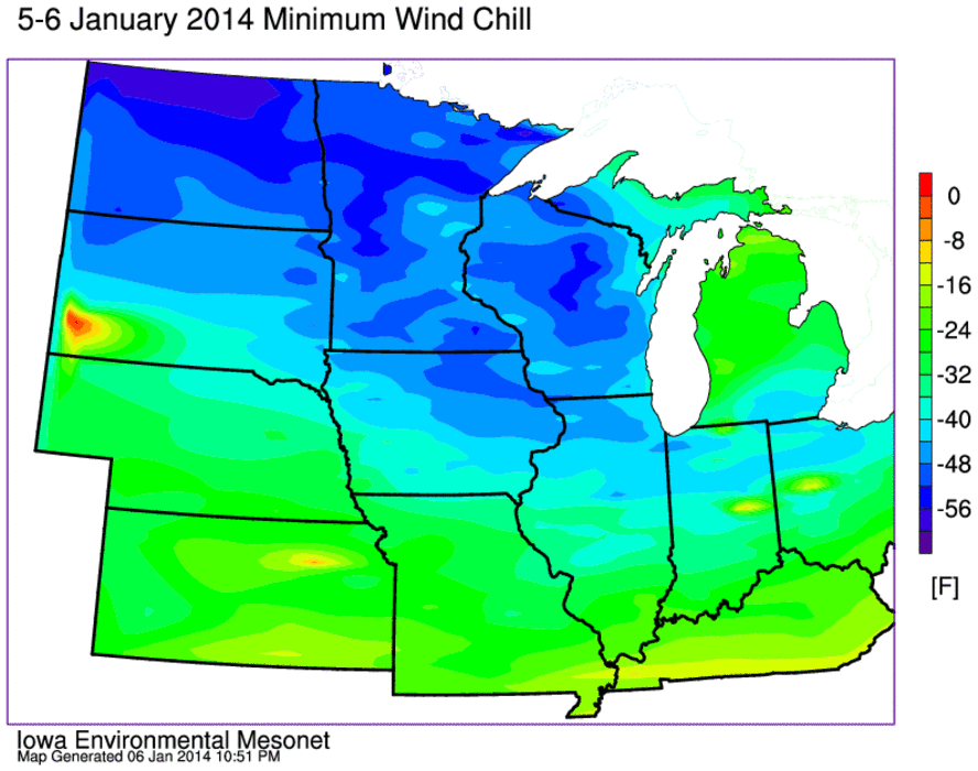
06 Jan 2014 05:39 AM
Much of the Midwest is in the firm grasp of winter this Monday morning with extreme cold and gusty winds making for life threatening conditions. Wind chill readings this morning are some of the coldest in many years. The featured chart presents the percentage of winter seasons that experience a given threshold wind chill reading for at least one hour that winter. Almost every year gets down to -20 with about half reaching -35. The extreme temperatures reached today will be in the 10% or lower frequencies, which means this is once in a decade or two weather.
Voting: Good - 61 Bad - 5
Tags: windchill
Tue Jan 07, 2014
Very cold wind chills
07 Jan 2014 05:44 AM
The featured map presents an IEM computed analysis of minimum calculated wind chill up until 12 AM 7 January. The lowest reading among the airport stations in Iowa was -51 from Oelwein. Most of the state bottomed out in the -35 to -45 range. Some even colder readings were found in Wisconsin, Minnesota, and North Dakota. A few isolated locations were able to reach -60! Temperatures will be on the rebound today with highs above freezing expected by later in the week!
Voting: Good - 27 Bad - 4
Tags: 2014 windchill
Wed Jan 08, 2014
Bone-chilling weather
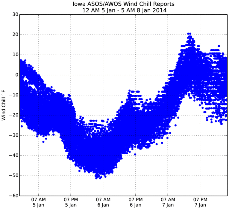
08 Jan 2014 05:45 AM
The featured chart presents a time series of recent calculated wind chill values from the automated weather stations located at airports in Iowa. While some locations are still quite cold this morning, most values are much warmer than they have been these past two mornings. The chart nicely illustrates that for a stretch on Sunday evening into Monday, the entire state was colder than -20 degrees for wind chill. The forecast has one more night of cold temperatures before moderation occurs and highs expected above freezing!
Voting: Good - 22 Bad - 5
Tags: 2014
Thu Jan 09, 2014

Comparing with 1983
09 Jan 2014 05:44 AM
The recent stretch of cold weather had a minimum wind chill of -45 degrees for Waterloo. The featured chart presents time series of wind chill using the current day equation for the ten coldest events for Waterloo. The most recent event is plotted as well for comparison. The coldest wind chill was associated with the epic Christmas Eve 1983 and is shown by the blue line. While temperatures were below -20 for two solid days this year, for the 1983 event they were close to or below -40 for three straight days! After another cold start this morning, temperatures will be improving with highs expected just above freezing on Friday for Waterloo.
Voting: Good - 26 Bad - 1
Tags: waterloo windchill 1983
Fri Jan 10, 2014

Daylight Duration and Change
10 Jan 2014 05:37 AM
While the days recently have been noticeably cold, they have almost been noticeably getting longer! Daylight time increase after the winter solstice (21 Dec) until the summer solstice on 21 June. The top panel in the featured chart presents the daylight time by day of year and the bottom chart presents the day to day change in daylight time. Three locations are shown to illustrate the difference with latitude. For daylight duration, the three lines intersect on the vernal and autumnal equinox as all locations on earth are at approximately 12 hours of daylight. For the daily change plot, the three lines intersect at the solstice as the rate changes sign for all locations on earth. It is kind of interesting to note how the daily change curve flattens out for Anchorage. The hand-waving explanation is that this is due to the trigonometry involved with the cosine function rate of change flattening.
Voting: Good - 83 Bad - 11
Tags: solar
Mon Jan 13, 2014

Getting to 50
13 Jan 2014 04:54 AM
It felt quite balmy on Sunday as high temperatures were above freezing and much warmer than our previous few weeks of weather. The high temperature for Des Moines hit 51, which was only seven days after having a high of -1. The featured chart presents the average number of days it takes to reach a high temperature of 50+ after a day with the given high temperature. The regression would indicate that the average time it takes for this to occur is around 30 days!
Voting: Good - 30 Bad - 6
Tags: highs
Tue Jan 14, 2014

Coldest of the winter
14 Jan 2014 05:37 AM
Was the recent stretch of cold weather, the coldest of the season? The featured chart displays the combination of coldest low and high temperature of the season with the day it occurred on. The lowest temperatures so far this season are shown in red. There is plenty of time for much colder weather and the forecast has a return to colder temperatures, but nothing like what we saw last week.
Voting: Good - 32 Bad - 7
Tags: winter
Wed Jan 15, 2014

Windy Tuesday
15 Jan 2014 05:42 AM
Winds were rather strong on Tuesday with numerous gusts over 50 miles per hour reported. Far northern Iowa also experienced snowfall with these windy conditions making for some difficult travel conditions. The featured chart presents the wind gust observations from automated stations in Iowa for Tuesday. Even stronger wind gusts are expected on Thursday with the arrival of some bitterly cold air again.
Voting: Good - 34 Bad - 4
Thu Jan 16, 2014
Pressure Gradient Winds
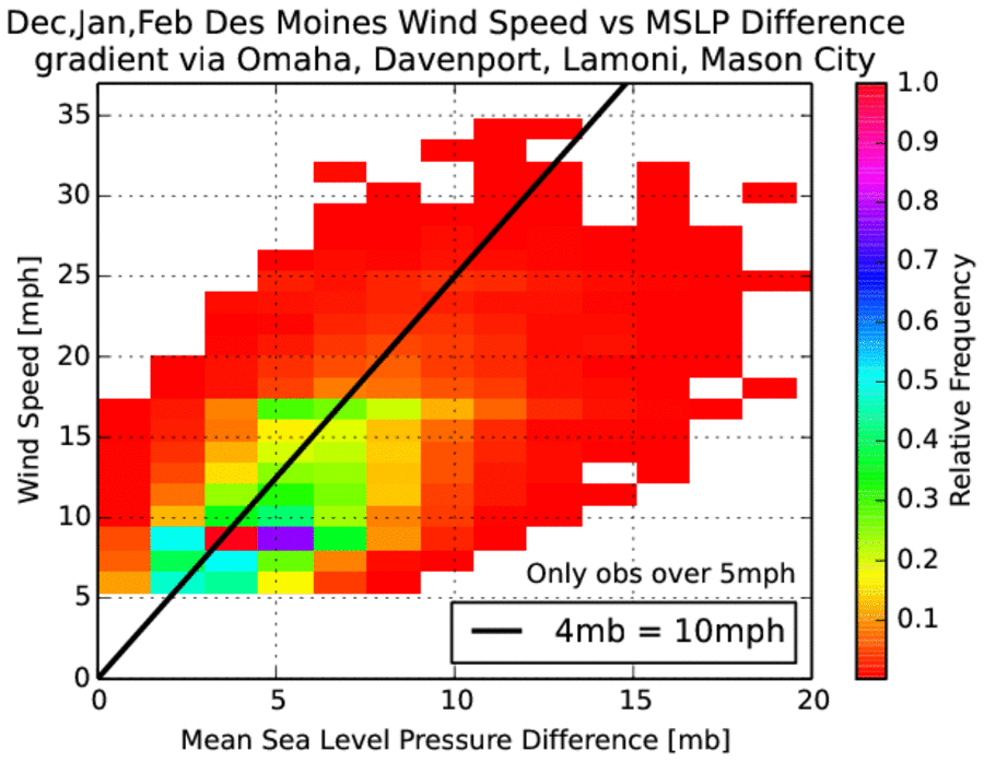
16 Jan 2014 05:55 AM
After a windy Tuesday, winds are on the increase today and expected to gust upwards of 50 mph. These strong winds are forced by horizontal differences in pressure as air moves from areas of higher pressure to areas of lower pressure. The featured chart presents the combination of an approximate pressure difference over the state to the observed wind speed for Des Moines. An informal forecasting rule of thumb is that for every 4 millibars difference in pressure over Iowa leads to a wind of 10 more miles per hour. For example, a 12 millibar difference should support a 30 mph wind speed. The chart would indicate that this is a fair approximation with most of the distribution near the theoretical line.
Voting: Good - 41 Bad - 7
Tags: forecasting wind pressure
Fri Jan 17, 2014

'13-'14 Winter Storm #11
17 Jan 2014 02:58 PM
A small amount of snowfall made for a tremendous impact over central Iowa on Thursday. Snowfall totals were generally less than three inches, but combined with rush hour traffic, strong winds, and pavement temperatures that were initially warm enough to melt the snow and then quickly freeze it, created for dangerous driving conditions. The city of Des Moines was especially hard hit by this storm with blizzard conditions existing during peak traffic hours Thursday evening. The good news is that warmer temperatures and sunshine will make quick work of this snow and ice over the weekend.
Voting: Good - 18 Bad - 8
Tags: winter1314
Sat Jan 18, 2014
That escalated quickly
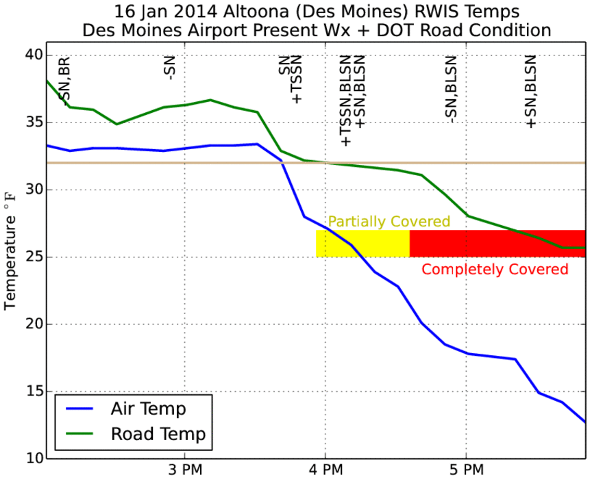
18 Jan 2014 05:49 AM
The featured chart is an attempt to explain why only a few inches of snow caused so much trouble for Des Moines on Thursday evening. The green line is the pavement temperature and blue line is the air temperature as observed by the Altoona RWIS site. The text abbreviations at the top are present weather reports from the Des Moines Airport sensor. (SN = snow, TSSN = thunder snow, BLSN = blowing snow, and the plus/minus indicate intensity with + being more intense than -) The colored blocks are the reported road conditions by the DOT for the location. The plot shows that prior to thundersnow report at 4 PM, temperatures were above freezing and the pavement temperatures were close to freezing for 30-45 minutes after the heavy snowfall started while air temperatures plummeted into the teens. So the situation was the initial intense snowfall melted, but soon after froze as air temperatures were way below freezing. The result was a layer of ice that formed on the roadways. The timing was terrible as well with this happening after 4 PM (the start of rush hour traffic). The plot does not show the intense wind speeds, which were creating ground blizzard conditions at the time.
Voting: Good - 62 Bad - 15
Tags: rwis 2014
Mon Jan 20, 2014

'13-'14 Winter Storm #12
20 Jan 2014 07:56 AM
This past Saturday saw yet another "clipper" system bring a quick shot of rain, sleet, and snowfall. Snowfall totals over extreme northeastern Iowa reached six inches. The large scale weather pattern that has produced the historic drought in California is oriented to continue to usher down these clipper systems that produce snow and quickly move out. The next such system arrives tonight with very cold air behind it with highs tomorrow in the single digits.
Voting: Good - 16 Bad - 4
Tags: winter1314
Tue Jan 21, 2014

Windy January
21 Jan 2014 05:38 AM
Average wind speed so far this January has been on the high side of long term average as shown by the featured chart. This has been the windiest 1-20 January period since Jan 1997, which is interesting as this season has been comparable to the fall and winter of 1996-1997 (more on this in future features). The windy conditions have helped to usher in brutal cold and some refreshing warmth so far this January. We are currently getting the cold end as temperatures and wind chills are very cold this Tuesday morning.
Voting: Good - 28 Bad - 7
Tags: jan jan14
Generate This Chart on Website
Wed Jan 22, 2014

'13-'14 Winter Storm #13
22 Jan 2014 05:40 AM
And yet another storm system producing snowfall is in the books. This round only brought a dusting to most of Iowa with amounts of 1-3 inches in some locations. This snow was thanks to yet another fast moving clipper system that have been common this winter season. Warmer temperatures have crept back into the state overnight, but will be quickly ushered away again with cold air arriving after the next round of light snowfall. This pattern looks to continue into February.
Voting: Good - 23 Bad - 7
Tags: winter1314
Thu Jan 23, 2014

Days below zero
23 Jan 2014 05:39 AM
Our brutal winter continues this Thursday morning with temperatures yet again below zero and wind chill readings much colder than that. For Waterloo, this makes for the 22nd day with a low temperature below zero Fahrenheit. The featured chart displays the number of days each winter season that the temperature was below zero. The bars are partitioned by the period before 24 Jan and then after. This season's total is the largest since 1983- 1984, but is a ways behind the epic winters of 76-77 and 77-78. There is still plenty of winter to go and the near term forecast continues the reinforcing shots of cold air.
Voting: Good - 34 Bad - 9
Tags: subzero
Fri Jan 24, 2014

January Headlines
24 Jan 2014 05:38 AM
It has been a busy month for the NWS with numerous rounds of snow, windy conditions, fog, and bitter cold requiring weather watch, warnings, and advisories to be issued. The featured chart presents these products issued by the Des Moines NWS Office so far this month. There are 26 headlines shown with the bars representing the time duration of the product. The largest break between products was during the 11-13th period. It would appear that more headlines will be necessary next week with yet another significant push of cold air hitting Iowa.
Voting: Good - 80 Bad - 19
Tags: jan14
Generate This Chart on Website
Sun Jan 26, 2014

'13-'14 Winter Storm #14
26 Jan 2014 02:14 PM
And yet another fast moving winter storm system dumped a bit of snow over Iowa on Saturday with the highest totals approaching four inches. These totals are not associated with the ongoing blizzard impacting Iowa on Sunday, but the deposited snow is being blown around by the intense winds associated with Sunday's storm. The winter storms continue in rapid succession with the current orientation of the upper level atmospheric flow stuck in a pattern that brings us quick shots of snow.
Voting: Good - 21 Bad - 5
Tags: winter1314
Mon Jan 27, 2014

January Departures
27 Jan 2014 08:21 AM
Sunday was a wild weather day in Iowa with chinook winds pushing temperatures well above freezing for much of the state during the afternoon hours, while the rest suffered blizzard conditions. The Arctic Front eventually dropped south and put the entire state back in the deep freeze with strong winds. For Des Moines, the high temperature of 49 was well above average while the low temperature of 4 occurred around midnight and was below average. The featured chart presents the frequency of daily high and low temperature departures. Sunday's value is denoted with a 'x' on the chart. The highest frequencies on the chart do not occur at the origin (0 and 0), which is why many prefer to talk about average temperatures and not normal temperatures as the most frequent temperature are not at the mean value!
Voting: Good - 18 Bad - 8
Tags: jan
Tue Jan 28, 2014
Where there was snow, there was trouble
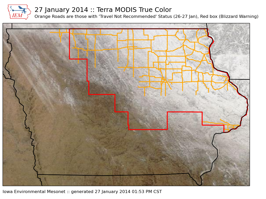
28 Jan 2014 05:43 AM
The featured map shows the combination of Terra MODIS true-color satellite on Monday, outline of the blizzard warning on Sunday, and roads that were in "travel not advised" status for the recent storm. While the entire state experienced strong winds and bitter cold, areas that actually had snow on the ground experienced the blizzard conditions. Some counties in the blizzard warning had zero travel concerns in the southwestern portion of the county, while the northeastern portion had blizzard conditions. The entire state is once again below zero with very cold wind chills.
Voting: Good - 37 Bad - 3
Tags: blizzard 2014
Wed Jan 29, 2014

Coldest January in a while
29 Jan 2014 05:41 AM
For Waterloo, the average temperature so far this January has been the coldest since 1994 and one of the colder ones on record. Averaging just 10 degrees is still much warmer than the epic cold of 1977-1979. Winds will be on the increase today and will bring in warmer air to help push temperatures back above freezing for much of the state. The next push of cold air is not far behind with highs on Friday back in the teens.
Voting: Good - 34 Bad - 3
Tags: jan14
Generate This Chart on Website
Thu Jan 30, 2014

Colder than Nome
30 Jan 2014 05:43 AM
The same large scale weather pattern that has kept the east coast stormy, the Upper Midwest cold, and the west coast dry, has kept Alaska warm this January. The featured chart compares the daily high temperatures for Waterloo against Nome, Alaska. For the month, the climatological high temperature is about 16 degrees warmer for Waterloo. This year has been a different story with Nome having a temperature 20+ degrees warmer on seven days so far this month. Before you consider moving to Alaska for warmth, this pattern will eventually shift with seasonal temperatures returning to both locations!
Voting: Good - 21 Bad - 6
Tags: alaska
Generate This Chart on Website
Fri Jan 31, 2014

'13-'14 Winter Storm #15
31 Jan 2014 08:01 AM
Our most recent fast moving winter storm brought a few inches of snow over northern Iowa, but also produced gusty winds which lead to some drifting again. Our next snow producing storm system is already here this morning and is expected to bring higher snowfall totals than this previous system. While we have been seeing numerous snow producing storm systems, the actual snowfall totals have been rather light. Today's storm will approach us from the southwest, which allows it to potentially work with more moisture and thus produce more snowfall.
Voting: Good - 52 Bad - 15
Tags: winter1314