Past Features
This page lists out the IEM Daily Features for a month at a time. Features have been posted on most days since February 2002. List all feature titles.
Mon Dec 02, 2013

Frozen November Periods
02 Dec 2013 05:37 AM
Much of the last part of November was rather cold with high temperatures some days struggling to break freezing. For Des Moines, a period of 92 hours experienced sub freezing temperatures during the month. The featured chart presents the longest such period during November for each year back to 1936. This year's period was the longest since 1996. The first week of December looks rather interesting with some portions of the state experiencing very warm temperatures and others stuck with colder temps. Everybody will be cold by the coming weekend with daily highs back below freezing.
Voting: Good - 26 Bad - 6
Tags: freezing nov
Tue Dec 03, 2013

Forecast Ranges
03 Dec 2013 05:38 AM
The forecast for the beginning of this week has been difficult to pin down as models have advertised wildly varying temperatures. The featured chart shows the range of forecasted daytime high temperature and overnight low temperature based on NAM Model Output Statistics (MOS) for Des Moines. The MOS output attempts to take raw numerical model output on a grid and tailor it for specific locations where observations are available. The range plotted is produced by looking at the various forecast model runs leading up to a day. The dots represent what actually happened. The forecast for today is shown as large bars, meaning the models have produced a wide range of values over time leading up to today. A more definite forecast is that it will get cold later this week, so enjoy whatever happens today!
Voting: Good - 29 Bad - 9
Tags: mos
Generate This Chart on Website
Wed Dec 04, 2013

Fog and afternoon temps
04 Dec 2013 05:46 AM
Fog was common yesterday over Iowa and continues this morning as a major winter storm organizes. The featured chart presents the frequency of having the maximum afternoon temperature above the average daily high temperature when fog was reported at the 6 AM observation that day for Des Moines. The general signal is for fog in the winter time to be associated with warmer than average afternoon temperatures. Correlation is not causation and foggy conditions in the winter time are typically a sign of being on the warm side of a passing storm system. The cold side of the storm system will arrive today and take the fog with it. So enjoy the fog and slightly warmer temperatures while they last!
Voting: Good - 19 Bad - 8
Tags: fog
Thu Dec 05, 2013
Higher and Lower Pressure
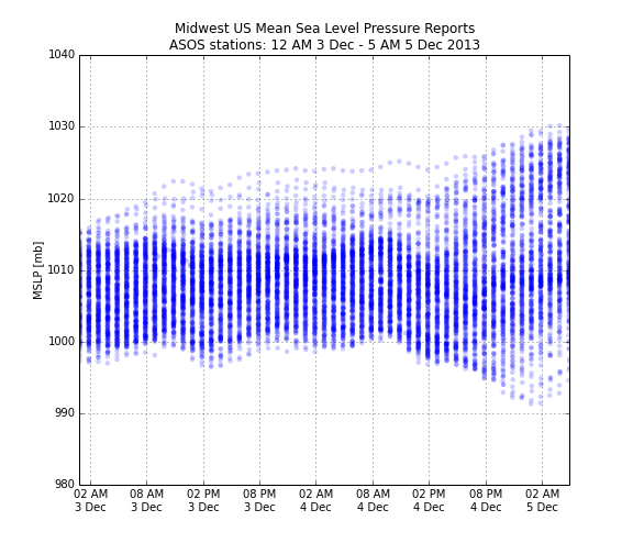
05 Dec 2013 05:49 AM
Low pressure systems get all the publicity as they are the ones that bring the precipitating weather and are called storm systems. On Wednesday, such a system rapidly deepened over the Midwest before departing to our north early this morning. The featured chart displays the reported mean sea level pressure values from the airport weather stations over the Midwest since Tuesday. It is interesting to notice that while pressure was dropping over some sites, other sites were experiencing an increase in pressure as the high pressure system moved in from our west and strengthened as well. We typically do not think of high pressure systems strengthening at the same time the low pressure system is deepening as well. These changes help to increase pressure gradients, which ultimately drive increased wind speeds.
Voting: Good - 33 Bad - 5
Tags: mslp pressure
Fri Dec 06, 2013

Ice Storm Warnings
06 Dec 2013 05:46 AM
The big weather story for the country is the ongoing winter storm impacting the southern US. Significant accumulations of ice are occurring from Dallas northeast thru Memphis. The National Weather Service has an Ice Storm Warning issued for portion of Arkansas, Oklahoma, and western Tennessee. The featured map presents the number of ice storm warnings by NWS forecast zone since late 2005. These types of warnings are rather rare with the largest number issued being only 9. There are some caveats to this map as local NWS offices have choices on many types of winter storm products to issue. Some will issue winter storm warnings when the ice comes with snow as well. Regardless, these types of events occur over areas with strong temperature contrasts as warm air from the south overrides cold air from the north. Unfortunately, another winter storm will impact the area later this weekend and perhaps bring some snow to Iowa.
Voting: Good - 81 Bad - 15
Tags: ice
Mon Dec 09, 2013

'13-'14 Winter Storm #4
09 Dec 2013 08:17 AM
Our most recent bout with falling snow is over this Monday morning with the featured map showing an analysis of snowfall reports. The highest totals just over five inches were just to the west of Des Moines. Totals of two to four inches were common over much of the rest of the state. Is there a chance that this snow could stick around until Christmas? The near term forecast continues the very cold weather.
Voting: Good - 30 Bad - 6
Tags: winter1314
Tue Dec 10, 2013

White till Christmas?
10 Dec 2013 05:45 AM
With the ground covered in snow and freezing temperatures in the forecast, could our current snow cover make it to Christmas Day? The featured chart presents the duration of snow cover when it was present on 9 December for Des Moines. Christmas is shown at 50%, meaning that half of the years with snow cover on the 9th had that snow stick around until Christmas. 25% of the the years had the snow stick around until the first of February even! Winter is in firm control of our weather with even colder weather expected tomorrow.
Voting: Good - 23 Bad - 2
Tags: snowcover
Wed Dec 11, 2013

Colder with snow cover
11 Dec 2013 05:45 AM
The featured chart shows the daily averaged difference in temperature between days with snow cover and with out. The temperature difference is for the next seven days after the analyzed date. The chart is attempting to show the temperature effect when there is snow cover versus not. The approximate average of the chart is negative five degrees, meaning that the presence of snow cover on a given winter day produces, on average, a next seven day period that is five degrees cooler than the same period when the first day is snow free. The results are intuitive as snow cover helps temperatures cool more rapidly at night and prevents incoming sunshine during the day from heating the ground. Our weather is going to remain very cold with our current snow cover that is being added to this morning with our most recent round of winter weather.
Voting: Good - 31 Bad - 6
Tags: snowcover
Thu Dec 12, 2013

'13-'14 Winter Storm #5
12 Dec 2013 05:36 AM
The snow producing winter storms have been coming at a rapid rate with the most recent round dumping upwards of five inches. This storm was accompanied by gusty winds and bitter cold temperatures. The good news is that temperatures are already on the rise this morning thanks to southerly winds and will be in the 20s this afternoon! The bad news is that we look to remain below freezing for the foreseeable future.
Voting: Good - 26 Bad - 4
Tags: winter1314
Fri Dec 13, 2013

Cold Stretches
13 Dec 2013 05:43 AM
Temperatures finally returned to reasonable levels on Thursday with some lucky locations in Iowa hitting 30 degrees! This was the warmest it has been in just over seven days. The featured chart looks at the longest period below a given temperature based on hourly temperature data for Des Moines, Sioux Falls, and St Louis. The north - south geography holds with Des Moines experiencing durations in between longer ones for Sioux Falls and shorter ones for St Louis. The current stretch of weather below 31 degrees has many days to go before besting the longest stretch of around 31 days. The forecast calls for warming to above freezing next week.
Voting: Good - 60 Bad - 11
Tags: winter freezing cold
Sun Dec 15, 2013

'13-'14 Winter Storm #6
15 Dec 2013 11:48 AM
And yet another winter storm impacted Iowa late last week with the heaviest totals over extreme southeastern Iowa. There was also much lighter snowfall totals over northwestern Iowa. Some light snow is falling in Iowa this Sunday with totals not expected to amount to much. The good news is that some warmer weather is expected this week before we plunge back into very cold temperatures next weekend.
Voting: Good - 72 Bad - 6
Tags: winter1314
Tue Dec 17, 2013

Below Average December
17 Dec 2013 05:35 AM
The first half of December has been well below average with temperatures running four to twelve degrees cold. The featured map shows an IEM computed analysis of average temperature departure for this year versus the past 63. The coldest departures have been over northwestern Iowa. Some warmer air is expected this week before our next round of very cold winter air arrives for the weekend.
Voting: Good - 31 Bad - 4
Tags: dec13
Wed Dec 18, 2013

Big Jump Up
18 Dec 2013 05:37 AM
After a very cold stretch of weather, temperatures warmed nicely on Tuesday into the 30s and are expected to reach the 40s for much of Iowa on Wednesday. Today's high is expected to be ten degrees warmer for Des Moines than the warmest high over the past thirteen days. The featured chart presents the largest increase in daily high temperature for a day vs the maximum over the previous thirteen days. The largest change shown occurred on 14 Feb 1899 with a high of 47 after a previous thirteen day high of 17. The chart shows a clear annual signal as these types of events are favored in the late spring as warm air mass surges replace persistent cold air masses probably associated with a snow pack.
Voting: Good - 32 Bad - 5
Tags: highs
Thu Dec 19, 2013

Warmup hurts snow chances
19 Dec 2013 05:38 AM
Temperatures warmed very nicely on Wednesday with highs some 15-20 degrees above average for some parts of the state. Are such warm conditions in the winter typically followed by snowfall? The featured chart presents the frequency of having at least one day of measurable snowfall for the three days following a day with the given high temperature departure. These values are only presented for dates during December, January, and February (DJF). A rather smooth signal appears in the chart with the highest frequencies at temperatures below climatology and warmer than average temperatures leading to a decrease in frequency. There appears to be an interesting inflection point around +20 degrees above average whereby frequencies actually increase. This can probably be explained by the most extreme temperature warm ups being associated with intense storm systems that bring colder weather and snow with the cold front passage.
Voting: Good - 33 Bad - 4
Tags: snow winter
Fri Dec 20, 2013

Freezing Rain Profiles
20 Dec 2013 05:39 AM
Much of Iowa experienced freezing rain on Thursday evening and into Friday morning. Freezing rain happens when liquid water, in the form of rain, is able to reach the surface and then freeze as the physical surface and air temperature are both below freezing. In this situation, the layer of below freezing air temperature needs to be shallow otherwise the rain drops will freeze and hit the ground as sleet. The featured chart looks lower atmosphere soundings from the Omaha site during events of freezing rain reported at the Omaha Airport. The cases shown depict the classic freezing rain signature of having a shallow layer of freezing temperature air near the surface with another layer of above freezing temperature air above it. The left hand plot presents the profile of temperature for the 45 cases used in this analysis, including the event from Thursday evening. The right hand plot depicts the level of the warmest temperature for each of those cases. The warm layer of air is centered just a few thousand feet above the ground at temperatures typically above freezing. What would be snow falls into this warm layer, melts and reaches the ground as liquid water. Note: since the case selection was based off of automated data, some of the profiles shown may not have been producing freezing rain.
Voting: Good - 83 Bad - 16
Tags: freezingrain sounding
Mon Dec 23, 2013

'13-'14 Winter Storm #7
23 Dec 2013 05:37 AM
The most recent snow storm brought the most significant totals of the season so far with the highest amounts over southern Iowa around nine inches. The freezing rain event of late last week did not help matters any as side streets remain very slick from the ice that remains and now the new snowfall. A white Christmas looks to be assured for much of the state now as temperatures will plummet Monday evening with the coldest air of the season arriving.
Voting: Good - 51 Bad - 2
Tags: winter1314
Tue Dec 24, 2013

Last sub zero temps
24 Dec 2013 05:45 AM
A very cold air mass, fresh snow pack, and clear skies are helping temperatures to plummet this Tuesday morning. Lows this morning are below zero Fahrenheit for the entire state with some locations pushing values below negative 20! The featured chart presents the period for Des Moines since the last temperature as cold as the given threshold. This morning's lows would be the coldest since the first week of January back in 2010. The good news is that warmer air is expected for the rest of this week with highs even approaching 30 degrees!
Voting: Good - 44 Bad - 9
Tags: winter lows
Thu Dec 26, 2013

Coldest since
26 Dec 2013 07:20 AM
Low temperatures on the morning of Christmas Eve (24 Dec) were some of the coldest readings in three to four years over much of the state. The featured map displays reported low temperatures that morning and the number of years or just months since the last temperature that was as cold. The good news is that day time high temperatures are expected above freezing for much of Iowa, but the next present from the Arctic arrives this weekend.
Voting: Good - 46 Bad - 8
Tags: dec13
Fri Dec 27, 2013

Back above freezing after low
27 Dec 2013 05:44 AM
After very cold low temperatures on the 24th, highs the next day were back above freezing! The featured chart presents the frequency of having an above freezing high temperature for at least one of the three days following a day with the given low temperature. A linear relationship exists until temperatures reach negative five or so and then the frequencies flatten out. This would indicate that it does not matter how cold temperatures get once they are below negative five. The physical reasoning for this may be that cooling below this level is a local radiation effect and not indicative of a more intense cold air mass which would decrease the chances of returning to above freezing temperatures in the near term future.
Voting: Good - 69 Bad - 12
Tags: lows winter
Mon Dec 30, 2013

64 degree drop
30 Dec 2013 05:44 AM
The warm up this weekend was replaced by very cold air on Sunday. After setting a record high temperature on Saturday for Sioux City at 62 degrees, it was -2 less than 24 hours later! The featured chart presents the largest downward temperature swings for the site as recorded by the hourly observations. The only event with a larger change was back in 1982 as the temperature went from 83 down to 18 between 2 and 3 April. Our weather pattern looks to be active this week with numerous chances of snow.
Voting: Good - 56 Bad - 15
Tags: coldfront temps
Tue Dec 31, 2013

'13-'14 Winter Storm #8
31 Dec 2013 07:40 AM
Our most recent bout with a snow producing storm system dumped just a few inches of fluffy snow over Iowa. The highest totals were south of Waterloo. This snow caused a number of traffic headaches as very cold temperatures made keeping roads clear difficult. Another snow producing storm arrives today and is expected to dump a bit more snow than this storm over northern Iowa.
Voting: Good - 27 Bad - 3
Tags: winter1314