The featured chart displays the April temperature percentile from the
first of the month to the given date. So on April 10, the average
temperature was above the 80th percentile for the 1-10 April period.
This value plunged for the rest of the month and finished cooler than
average below the 40th percentile. May has not started much better
with a cool northwest breeze and near freezing temperatures this
morning. Really warm air is nowhere in the immediate forecast period!
Clear skies and low dew points helped temperatures drop to well below
freezing over a good portion of Iowa this morning. It is not that
exceptional to have this cold of weather for the 3rd of May as we are
just now getting out of the period where we would expect our last frost
of the season. The good news is that our weather has been mostly dry
recently allowing some field work to be done, but without warmer
temperatures, the crops will not grow.
Iowa is experiencing another chilly May morning with lows in the 20s
and 30s. For some locations, the lows experienced over the past two
days have been colder than the coldest daily low temperature in April.
This situation is very rare and has only happened during a couple of
years since 1893. The featured plot compares the coldest temperature
in May against April. A negative value would mean the May lowest
temperature was colder than April. Warmer weather is set to return
today, but with it will come chances of rain!
Our recent stretch of weather from mid April has seen us struggle to
reach 60 degrees. The last two days have seen much warmer temperatures
and the forecast is calling for even warmer temperatures in the 70s and
80s next week. There are continued chances of showers, but nothing too
heavy. This weather will help farmers catch up on planting!
Dew points are on the rise this Monday morning with some of the highest
values we have seen in the past three weeks reported. The featured
graph presents the simple average dew point value since mid April for
this year and previous ones. This year's value is the lowest since
1997. The return of moisture today looks to stick around for the week
helping to keep chances of rain going just about each day.
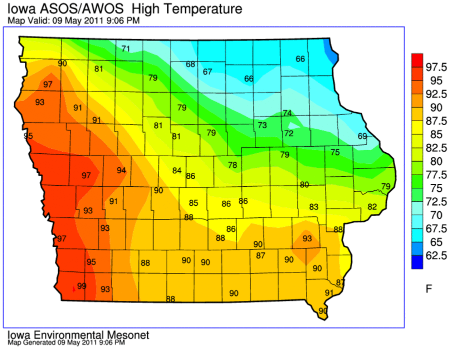
Very warm air finally returned to Iowa on Monday with highs in the 90s
over the western portion of the state as shown by the featured map.
The northeastern portion was not as lucky with highs only in the 60s
thanks to morning rain showers. The warm air continues today with good
chances of breaking record high temperatures.
Tuesday brought an early taste of summer with high temperatures well
into the 90s and dew points in the upper 60s! Record highs were set
all over the state with the featured map showing reported highs from
the NWS COOP network. One site in the network (Jefferson) reported 100
degrees, which is a very rare event for May. It has been 10 years
since our last 100 degree temperature in May. More muggy weather is in
store for the next few days before a cool down for this weekend.
Strong thunderstorms brought large hail and a few tornadoes to the
state yesterday. They also brought much needed rainfall to locations
like Ames, which had been dry since the later part of April. The
featured chart shows the daily rainfall reports by the Ames Airport
along with the departures from climatology. Yesterday's rainfall got
Ames back to even for the period starting on 1 April. More rain is in
the forecast with much cooler weather expected this weekend.
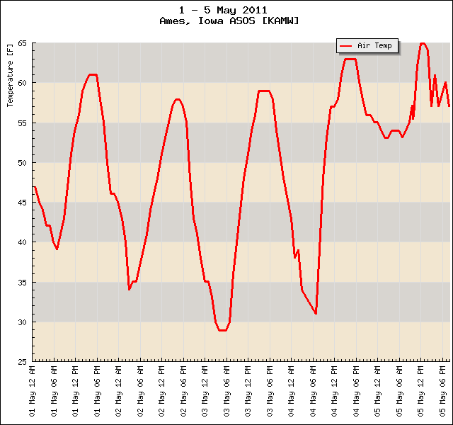
This week has seen very warm weather for early march with highs topping
out on Tuesday in the lower 90s for Ames. Much cooler air has arrived
just in time for the weekend thanks to a passing storm system. The
featured chart shows our hourly temperatures for this week and a
forecast from one of the government models called GFS. It looks like
we are back in the regime of struggling to reach 60, but warmer weather
is set to return next week along with some sunshine.
This weekend saw temperatures struggle to reach 50 on Saturday and 60
on Sunday thanks to cloud cover and northerly winds. The featured
chart presents the wind direction and air temperature since 15 April
for Ames. The observations where the winds were from a direction
between south and west are highlighted in red. These winds typically
bring us warm air this time of year. This week will start off with
plenty of sunshine and slowly warming temperatures.
After a miserable weekend, Monday was very nice with clear skies and
warmer temperatures. There was also abundant dry air which makes for
good conditions for satellites to peer down at us and capture beautiful
shots such as the featured image from MODIS. Another clear day is
expected today!
The featured chart is a timeseries from the Cantril RWIS site showing
air, pavement, and sub surface temperatures since last Thursday. The
impact of having sunny days on temperatures can clearly be seen with
the textbook delayed response as you go deeper into the ground. The
black dashed line is the temperature at 60 inches which was warming
this past weekend while everything else was cooling off. While the
impacts of sunshine near the surface have a daily signal, the deeper
you go the slower things vary. You can even notice the difference
between 8 and 16 inches.
Our winds are again out of the east this morning with an approaching
storm system to our west. These winds are not as warm as those from
our southwest. The featured chart presents the number of unique hours
during which a wind observation of at least 5 knots was reported by the
Des Moines ASOS since the first of April. Since 1973, this calculation
would indicate that this year has seen the fewest number of hours.
Showers and thunderstorms are visiting the state this Friday morning
and are expected to stick around for most of the day. This comes after
a dry Thursday for Ames. The featured chart displays the average
weather for Ames by day of the week for the past year. Thursday has
been remarkably dry compared to the other days, including Friday. The
upper chart displays the frequency of having a high temperature above
climatology for the day. So while Thursday's have been drier, they are
also cooler!
The weather was severe on Sunday over a large portion of the country.
The featured chart presents the combined number of counties under
either a tornado or severe thunderstorm watch at a given time. The
total combined area of those counties is presented as well. At 3:45 PM
yesterday, 445 counties were in watches covering an area larger than
Texas! According the IEM data, the largest number of counties under
watch in the past 6 years was 785 during the recent outbreak over the
south on 27 April.
Prior to yesterday, the high temperature for Ames had only warmed to 70
degrees or greater 15 times this year. This is a relatively low number
compared with other years with only 1993 having fewer days since 1990.
The featured chart compares the number of days above 70 prior to
yesterday to the number of days above 90 for the rest of the year.
Since 1990, the largest number of days over 90 was 22 days in 2005.
Highs are expected to approach 80 today with cooler weather arriving
for the rest of the week.
The parade of severe weather outbreaks continued yesterday with
numerous tornadoes reported in Oklahoma and Kansas. This was thanks to
a very large storm system that shows up on visible satellite this
morning centered over Kansas. More severe weather is expected today,
but Iowa will miss out on most of it with the primary impact being
continued heavy rains.
Our recent stretch of showers and thunderstorms have dumped some heavy
rainfall totals over portions of southeastern Iowa, while extreme
northwestern Iowa has missed out. The featured map is of estimated
precipitation for the past 72 hours from a NOAA project abbreviated
NMQ. Totals over 6 inches are depicted. More rain is in the forecast
for today.
The featured chart displays the number of tornado warnings issued by
the NWS for each day this year. There have been 9 days with over 100
warnings issued per day. In total, there have been 3,147 tornado
warnings issued so far this year. This total is only about 300 warnings
shy of the entire year's total for 2010.
The unofficial start to summer is today and the summer-like muggy air
has returned just in time. The featured chart presents dew point
observations so far this month and the spike upwards yesterday was
thanks to a warm front that made it into Iowa late Sunday afternoon.
Dew point readings were the warmest since the second week of May.
Strong southerly winds brought warm air into the state on Monday making
for a warm Memorial Day. The featured chart looks at the high
temperature and daily average wind speed for recent Memorial Days. It
has not been much warmer nor windier, since 1971. A front is bringing
drier air into the state this morning, but the sticky air will return
soon for the rest of the week.