The three months of the year known as meteorological winter are now in
the books and preliminary data shows that high and low temperatures
were below average for the period. The featured chart presents these
averages and the last four winters have been on the cold side. But
now we can focus on March and hopes for a warm spring! March will
begin like a lamb with highs in the 40s today.
The first day of March was a very pleasant day with sunshine and
temperatures in the upper 40s and 50s. One almost forgot about winter
and hoped the end of meteorological winter was the end of the actual
winter season as well. But then, a cold front swept the state during
the evening and dropped temperatures below freezing and a brisk wind
pushed wind chills to values below zero in some locations. The
featured chart shows the change for Denison from a high yesterday of
57 to a wind chill of -5 this morning.
The numbers on the featured plot show the yearly average March
temperature for Iowa. The location of the number represents the
spatial center of mass for all the severe thunderstorm and tornado
warnings issued for March during that year. The map is attempting to
show the relationship between average temperature in Iowa to the
favoured are to where severe weather happens. The warmest
temperatures mostly appear to the west and north in this map, which
makes some logical sense as warmer weather would promote severe
weather further north near Iowa. The coldest temperatures imply that
severe weather is pushed to the south away from the state. The limited
area of this plot also suggests that most of the severe weather
happens in this area during March.
Temperatures warmed nicely on Thursday pushing 50 degrees for Ames.
The featured chart presents the number of days with the high
temperature above 50 and the number with the high below freezing since
the beginning of the year. This winter has seen its fair share of
cold days with this being the fifth straight year with more than
average number of cold days. At this date last year, we had yet to see
50 degrees at all, so this year has been an improvement! Colder
temperatures are here for this weekend with highs back below freezing.
While the lengthening days and warmer temperatures of March can make
winter fell like it has gone away, the cold and snow of winter is still
common in March. The featured chart presents the partitioning of
yearly snowfall between dates prior to 1 March and those afterward.
The 1to1 line shows that getter more snow after 1 March than before is
rather uncommon, so our total so far of around 30 inches has little
chance of being doubled this spring. Getting another 3-12 inches is
common and the forecast this week looks to work on those totals with
heavy snow possible in Iowa on Tuesday.
Our next storm system is gathering to bring rain and snow to the state
on Tuesday into Wednesday. The featured chart is of different
forecasts of snowfall for the upcoming period for Mason City. The
totals range from 3.5 to 7.5 inches. A big question is if temperatures
will warm enough to support more rain than snow. There seems to be
little doubt that up to an inch of precipitation will fall over a good
portion of the state.
There has seemingly been no shortage of storms this winter season with
another large system impacting Iowa this evening. The featured chart
presents the areal coverage over Iowa of RADAR returns since the first
of December. You could consider each of the chart spikes as another
storm system. Outside of a quite stretch in February, the chart is
quite noisy indicative of the active winter.
Our latest winter storm is now in the books having dumped very wet snow
over a good portion of the state. Actual depths of snow did not get
too deep, but it was a very wet causing a lot of pain to move around.
The good news for snow-haters is that very warm air will make quick
work of this latest round of snow.
High temperatures are struggling so far today thanks to our recent
snowfall and being on the cold side of a departing area of surface high
pressure. The featured chart presents the high temperature for a day
after snowfall as recorded from the long term stations near Ames. The
favored temperature is clearly around or just below freezing, which
makes sense with all the newly deposited snow around. The greater the
snowfall, the more likely the next day temperature will be below
freezing, which makes sense as well. Much warmer air is set to arrive
tomorrow and rid us of most of this new snow.
A refreshing push of much warmer air make it into the state today and
sure makes things feel much more like spring, but is the spring season
actually here? If one thinks about winter as being the 91 (1/4 year)
coldest days of the year, then perhaps spring has already arrived. The
featured chart looks at the coldest (avg high+low) 91 day period for
Ames and a fit line is placed on the end of the period. The fit would
indicate that spring is coming a bit earlier than in the past. The
colors of the bars represent the quartile of the average temperature
for the winter season. A number of the bars push well into March, but
the forecast for the next week looks very warm, so based on this
metric, we are probably in spring now!
Temperatures struggled on Sunday to rise above freezing over a good
portion of the state. The featured chart presents the observed
frequency of having the high or low temperature below freezing for a
given day in March. While having low temperatures below freezing is
still very common for the 13th of March, having the high temperature
below freezing is a once every 5 years event. Warmer temperatures are
in the forecast for this with highs in the 50s and 60s!
For some of you, your clocks are now accurate again after our recent
switch back into Daylight Savings Time. Of course, we are not saving
anything as the hour of sunshine in the evening is at the expense of an
hour of sunshine in the morning. The featured image shows the
transport of sunshine into the evening hours. The devil is involved in
this process as it encourages an extra hour of sleep in the morning
before the sun-provoked rooster wakes you up.
The featured chart presents the highest forecasted surface based
convective available potential energy (CAPE) from the GFS model for a
grid point near Ames since the first of the year. This variable gives
an indication to the degree of instability in the atmosphere that helps
to facilitate thunderstorms. Values above 1,000 typically are when the
stronger storms are possible. While values shown are well below 1,000
for surface based air parcels, CAPE computed for elevated parcels is
expected to be larger and will allow for some hail producing storms in
the coming week.
Temperatures soared on Wednesday into the 60s for most of Iowa and a
repeat performance is expected today. Is it the luck of the Irish to
see two days above 60 in a row in March? The featured chart shows that
the probability of seeing a day above 60 after a day above 60 is around
50%, so we are only somewhat lucky! Temperatures return to near normal
values on Friday along with numerous chances of rain.
Temperatures on Thursday were again well above average for this time of
year. The featured map shows high temperature departures for the 17th
of March and Iowa enjoyed temperatures 15-30 degrees above average.
Cooler weather has returned today along with chances of rain, but
temperatures will stay above freezing to keep our snow chances at a
minimum.
Moisture has been on the increase to celebrate our start to the spring
season. The featured chart shows the observed dew point temperature
for the Ames Airport since the beginning of the year. The increase in
moisture is helping to fuel thunderstorms with some of them producing
hail on Sunday. Severe weather is possible for the next two days and
then much cooler weather expected for the rest of the week.
Storms bringing hail have been frequenting the state these past few
days with more expected today. The featured chart presents the
frequency of hail observations based on National Weather Service local
storm reports since 2003. The top chart shows hail to be most common
during the spring and summer months. The bottom chart shows the late
afternoon as being the most favored time for hail. The late afternoon
is typically when the atmosphere is at its most unstable condition
after the sun has heated the ground for most of the day. Hail can
occur at any time of day and certainly during the night time hours.
Iowa's first real taste of severe weather season arrived on Tuesday
with a powerful low pressure system pushing through the state late in
the afternoon. Numerous frontal boundaries were present over southern
Iowa late Tuesday afternoon and helped to spin up some brief tornadoes.
The featured image from Tyler Love of Creston shows the photogenic
tornado on the northwest side of town. Major temperature changes are
in store with a return to winter like conditions for the remainder of
the week.
The featured chart presents a recent time series of air temperature and
wind chill values for Shenandoah Iowa since Sunday. Very warm air for
this time of year has given way to a colder air mass with highs
expected to struggle in the 30s and low 40s for the next week! Average
highs should be around 50.
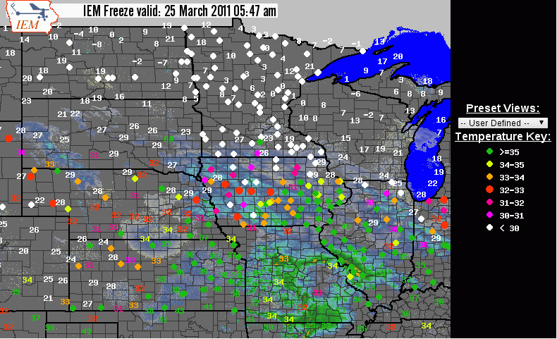
Snow is once again visiting the state today even after a day that
reminded us of spring with severe storms and tornadoes. The featured
map is from the IEM Freeze application showing the combination of
NEXRAD, RWIS pavement temperatures (dots), and air temperatures. Only
a few inches of snow will fall for some lucky few, but more chances of
snow are in the forecast along with cold temperatures.
While it was not much for a winter storm, it did dump upwards of 4
inches of snow over extreme southwestern Iowa and probably should be
included in the listing of storms for this winter season! Most of
this snow melted by later in the day. Heavier amounts occurred over
Missouri and more snow even fell today.
Our recent stretch of weather has seen high temperatures struggle in
the 30s, which is well below climatological average for this time of
year. The featured chart presents the number of days one would have to
go in order to match the current day's high temperature with
climatology. For example, the high temperature yesterday is what we
would have expected for a high 22 days ago. The warm days in February
stick out with one day having a high temperature that what our average
high is for mid April. Warmer temperatures are in the forecast for the
end of the week!
Our current stretch of seasonably cool weather continues with snow and
freezing drizzle frequenting the state this morning. The featured
chart shows high and low temperatures for Des Moines for the past 7
days along with climatology. That 60 degree temperature seems like an
eternity ago. There is hope that 50s will return this weekend!
The featured chart presents the combination of average high temperature
for the first seven days of April versus the last seven days of March.
This year's average is expected to end up around 42 degrees, which is
cool but not the coolest values shown on the chart. The average for
the first seven days of April is around 58 degrees and you can see that
only a few years with such a cool last part of March were able to be
above normal for the beginning of April.
Yesterday was a remarkably calm day for late March with the peak wind
speed reported at the Des Moines Airport (based on the hourly obs) of a
mere 8 mph. The featured chart presents the maximum reported wind
speed for each March 30th going back to the late 1940s. This year's
value is the lowest to be found on the chart. March will end with
another mostly calm day with a chance of rain. Blustery weather
arrives on Saturday!