Past Features
This page lists out the IEM Daily Features for a month at a time. Features have been posted on most days since February 2002. List all feature titles.
Thu Dec 01, 2022

Dry Dew Point Hours
01 Dec 2022 05:30 AM
Since the dew point temperature generally needs at or below the air temperature, the very chilly air on Wednesday was dry as well. Probably thanks to the ongoing drought situation, it feels like we have seen more than our fair share of dry air so far this season. The featured chart attempts to quantify that feeling by showing the accumulated number of hours at or below a given dew point temperature for Des Moines between the 1 July and 30 November period. Sure enough, our suspicion was correct with most of the values shown above a simple climatological average. It is interesting to note that for extremely dry dew point temperatures (below 10F), this season has seen a below average accumulation. The reason for this is likely more a function of lack of snow cover, which promotes lower temperatures generally unreachable with somewhat warm ground temperatures that are snow free.
Voting: Good - 9 Bad - 1
Generate This Chart on Website
Fri Dec 02, 2022
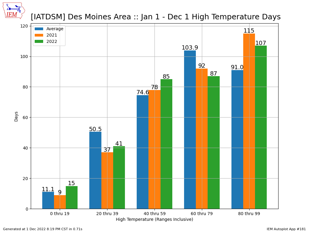
Partitioning of Highs
02 Dec 2022 05:30 AM
High temperatures on Friday are expected to be in the 50s before another strong cold front drops us back below freezing for Saturday. We seem to have had plenty of days recently with highs in the 50s and the featured chart seems to point out this anomaly. The chart shows the number of days per year within the given high temperature bin for Des Moines for the year to date period. The simple long term average is shown along with the totals for this year and last. It is interesting to see how far below average we have been for the 60 through 79 range, but well above for the ranges surrounding it. So perhaps one can say that we have been cheated out of pleasant days in the 60s and 70s this year, but given that it is December, having 50s is about as good as it can get!
Voting: Good - 14 Bad - 0
Generate This Chart on Website
Mon Dec 05, 2022
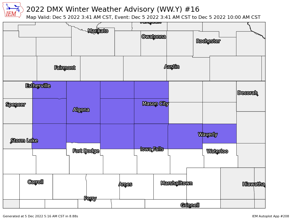
Winter Weather Advisory
05 Dec 2022 05:24 AM
The National Weather Service has a wild variety of products to cover various threats to life and property. The Winter Weather Advisory is one such product that covers the nuance events that often make for travel difficulties. NWS Des Moines has issued such a product for northern Iowa this morning with the featured map highlighting the counties included in the advisory that runs until 10 AM. These generated graphics are available for any of the archived watch, warning, and advisory products that contain the programatic Valid Time Extent Code (VTEC) encoding. If you are a fan of the twitters you can follow iembot_dmx, which contains a syndication of NWS products relevant for the Des Moines County Warning Area.
Voting: Good - 13 Bad - 1
Generate This Chart on Website
Tue Dec 06, 2022
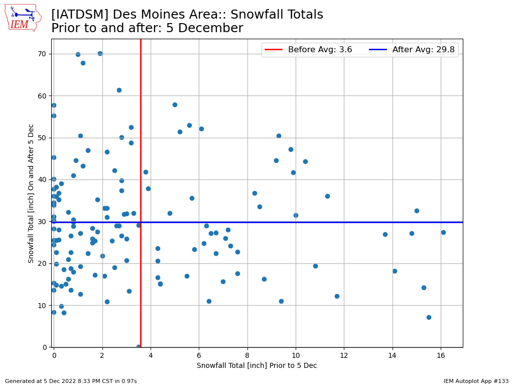
90% Of Snowfall To Go
06 Dec 2022 05:30 AM
If you consider the winter season by the accumulated snowfall received, then on average we are about 10% complete by 5 December. The featured chart presents the season snowfall total for Des Moines before 5 December and after. A lot of scatter is shown in the chart, so a fast or slow start to the season does not necessarily portend to it continuing. There is a lot of variability shown in the chart with both values as individual and significant snowfall events can heavily skew the season totals. There are chances of accumulating snow in the forecast for both this week and potentially next week as well.
Voting: Good - 8 Bad - 0
Tags: snowfall
Generate This Chart on Website
Wed Dec 07, 2022
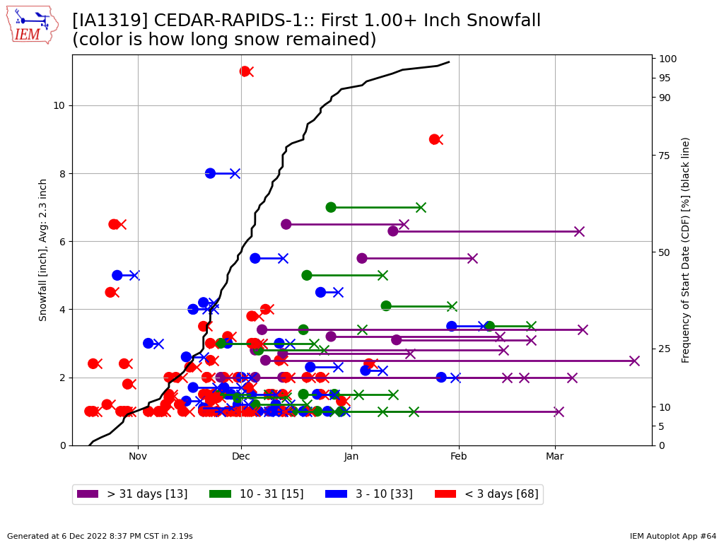
Cedar Rapids First Snowfall
07 Dec 2022 05:30 AM
Cedar Rapids picked up its first daily inch of snow back in mid November, but was mostly gone not too many days later. The featured chart presents the date of first inch snowfall and the number of days snow cover persisted afterwards. There is a wild amount of variability shown with this chart and anytime snow data is used, the standard caveats of data quality apply. The red dots and arrows indicate the snows that stuck around the least amount of time and it stands to reason to see most of those coming at the beginning of the season.
Voting: Good - 12 Bad - 0
Generate This Chart on Website
Thu Dec 08, 2022

Special Weather Statement
08 Dec 2022 05:44 AM
As a part of the National Weather Service's mission of saving life and property, they have a product called the "Special Weather Statement" to use as a catch-all for many types of impacts. The featured map presents an IEM generated summary of a recently issued Special Weather Statement from NWS Des Moines for dense fog over the eastern portion of their county warning area. These images are auto-tweeted to the @iembot_dmx twitter account, so that is one means to follow along. They are also included on the IEM text product page, which is the easiest way to generate them for past events.
Voting: Good - 10 Bad - 1
Generate This Chart on Website
Fri Dec 09, 2022
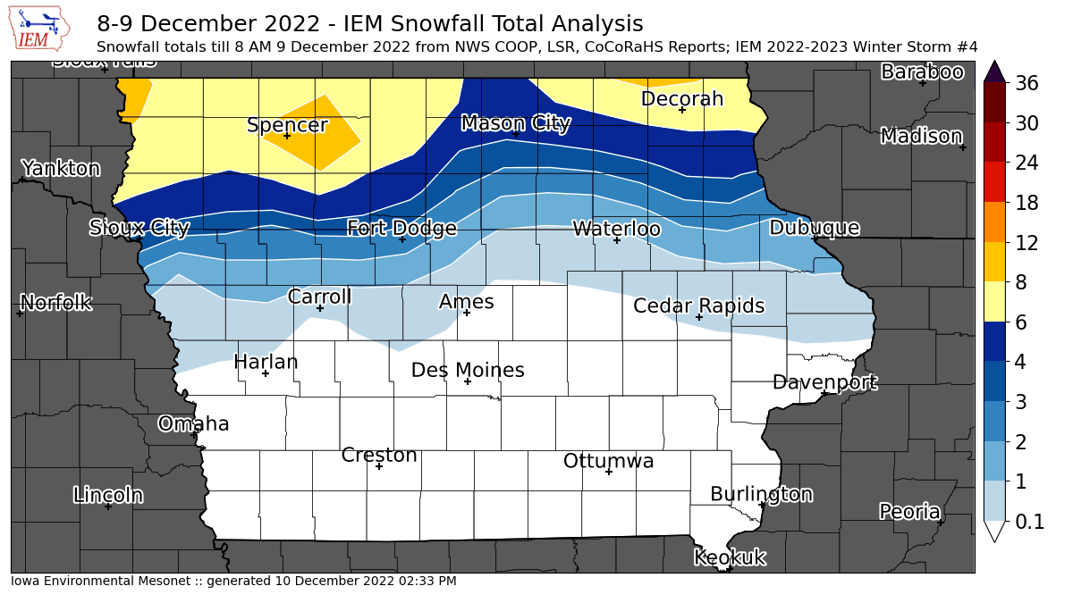
'22-'23 Winter Storm #4
09 Dec 2022 07:59 AM
The overnight winter storm is pulling out of Iowa this Friday morning with much needed moisture falling in the form of snow over far northern Iowa and rain in other places. The featured map presents a current analysis of available NWS COOP, LSR, and CoCoRaHS reports. One note is that far northeastern Iowa may be under-reporting here due to the snow still ongoing and reports made while heavy snow was in progress. So this map may get updated Saturday morning to include those reports. There was lightning and thundersnow observed with this event, which an old forecasting rule of thumb states that somewhere gets at least a foot of snow when that happens, so some isolated higher reports than the 6-8 inch band shows may have occurred.
Voting: Good - 17 Bad - 1
Tags: winter2223
Mon Dec 12, 2022

Little December Movement
12 Dec 2022 05:23 AM
Temperatures have been a struggle over the past number of days for much of Iowa thanks to persistent clouds and fog not allowing much movement in temperature. A case in point is Iowa Falls, whose past three days have seen at most a three degree difference between the daily high and low temperature. The featured chart presents the top ten smallest daily temperature changes for December and each of the past three days is listed! The spark lines shown on the right hand side present the available hourly temperature reports for a +/- 12 hour period around each day (denoted by the tan vertical lines). We should see some more movement in temperature today as a big storm system approaches from the west and winds increase in response.
Voting: Good - 10 Bad - 2
Generate This Chart on Website
Tue Dec 13, 2022
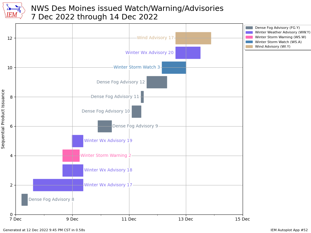
Week of Headlines
13 Dec 2022 05:06 AM
Today will continue the stretch of active weather with a powerful plains cyclone bringing strong winds, rain, some freezing rain, and snow. An illustration of this active weather period is shown by the featured Gantt chart showing the time duration of the various headlines issued by NWS Des Moines over the past seven days. Iowa presently has a Winter Weather Advisory, Wind Advisory, and an Ice Storm Warning (for a few far northwestern Iowa counties). The significant areas of snow and blowing snow look to stay well off to our north and west with this system, but an impactful ice storm is expected for NW Iowa.
Voting: Good - 13 Bad - 0
Tags: gantt
Generate This Chart on Website
Wed Dec 14, 2022

'22-'23 Winter Storm #5
14 Dec 2022 05:30 AM
Just to again emphasize, the IEM winter storm accounting are somewhat arbitrary and unofficial. The first wave of a large and powerful winter storm system brought freezing rain to northwestern Iowa and points north. The featured map presents NWS reports of ice accumulation in inches. Fortunately, temperatures warmed for Iowa during the day on Tuesday and mitigated more significant travel impacts. The same storm complex is expected to bring a chance of snow into Iowa on Thursday and into Friday.
Voting: Good - 11 Bad - 2
Tags: winter2223
Generate This Chart on Website
Thu Dec 15, 2022

Another wild December
15 Dec 2022 05:30 AM
December 2022 is picking up where December 2021 left off and producing plenty of severe convective weather. Another significant tornado outbreak during December happened yesterday over the southern end of the so-called "Dixie Alley". The NWS issued 106 tornado warnings yesterday, which matches the previous December record set on 10 December 2021. The featured chart presents the number of NWS Tornado Warnings nationwide by month since 1986. A big caveat is that data quality decreases prior to 2001 and really decreases as you go back into the early 1990s. That aside, it is interesting to compare the monthly totals and note that these past two Decembers saw more warnings than in the associated July's of each year. Thankfully, Iowa has yet to have a December repeat this year of what happened here last year on this date, 15 December 2021!
Voting: Good - 16 Bad - 0
Generate This Chart on Website
Fri Dec 16, 2022
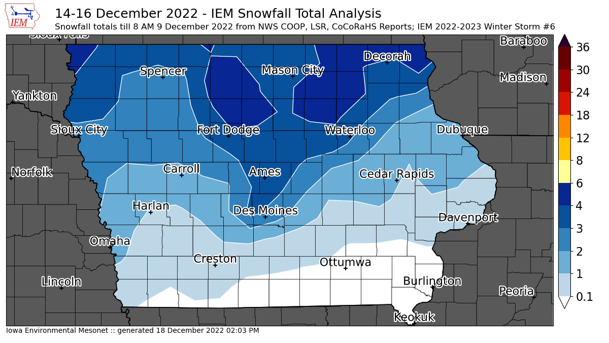
'22-'23 Winter Storm #6
16 Dec 2022 08:20 AM
A long duration snow event continues this Friday morning with the featured map attempting to total up available reports over the past two days. Totals were much higher to Iowa's north, but a persistent wind is blowing this snow around and making for tough travel conditions. This map will likely be updated later today or tomorrow as additional snow totals come in. Will this snow stick around until Christmas? The near term forecast does hold out hope for this with very cold weather expected to arrive later next week.
Voting: Good - 21 Bad - 1
Tags: winter2223
Mon Dec 19, 2022

Downward Glide in Temperatures
19 Dec 2022 05:30 AM
The featured chart is courtesy of the venerable BUFKIT Warehouse and presents various forecasts for air temperature this week for Des Moines. Whatever warmth you are able to capture on Monday should be cherished as temperatures are on the downward glide this week with the coldest air arriving along with Santa on Christmas morning. There will also be a couple of chances of accumulating snow, which is likely good news for those that want to ensure a white Christmas, but bad news for those wishing to travel to Grandma's house this week.
Voting: Good - 13 Bad - 0
Generate This Chart on Website
Tue Dec 20, 2022
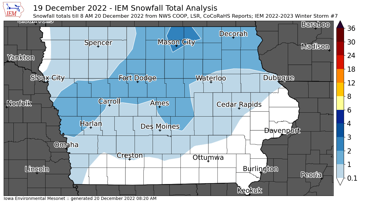
'22-'23 Winter Storm #7
20 Dec 2022 08:25 AM
While more of an annoying snowfall than anything, a light round of snow visited the state on Monday and into Tuesday. A few isolated two inch snowfall reports were found over far northcentral Iowa. The featured map presents an analysis of available NWS and CoCoRaHS reports. This snow was a bit of a messaging headache as the big storm arrives on Thursday and a massive winter storm watch is already in effect for it. Sadly, sometimes folks conflate the two events and think the forecast already busted due to the minimal snow that fell already. Anyway, the big and impactful storm is still on track. Please pay close attention to the forecast and realize that snowfall totals aren't necessarily important when winds are howling and wind chill temperatures are at life threatening levels!
Voting: Good - 12 Bad - 2
Tags: winter2223
Wed Dec 21, 2022

Deep Freeze Days
21 Dec 2022 05:30 AM
The near term forecast is nothing short of horrible with very cold temperatures and strong winds creating dangerously cold wind chills. The present forecast for Ames on Thursday and Friday have both days with a high temperature below zero. So your deep freeze, which is typically kept around 0°F, may be warmer than the daily high temperature outside! This would be the first such days this year. The featured chart presents the number of days per calendar year with the high temperature below 0°F for Ames. The long term simple average is just one day and there are plenty of years without such a day on record for the site. The yellow line shows a 30 year trailing average and there's not much change to be shown over the past decade.
Voting: Good - 13 Bad - 2
Tags: deepfreeze
Generate This Chart on Website
Thu Dec 22, 2022
'22-'23 Winter Storm #8
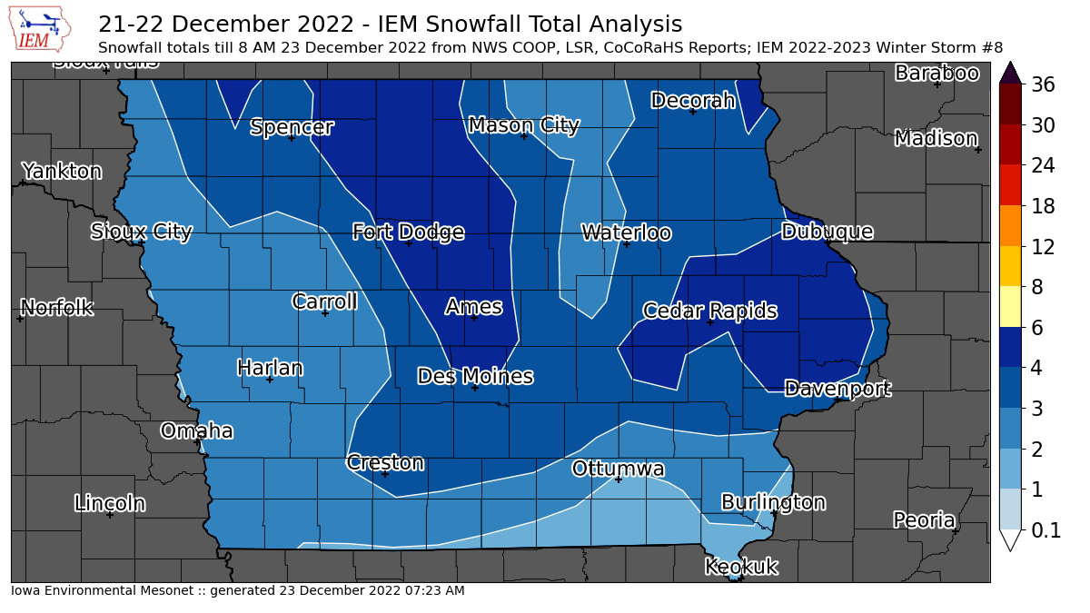
22 Dec 2022 10:07 AM
The snow is about done falling vertically, but is just getting started blowing horizontally. The featured map presents an analysis of available NWS and CoCoRaHS snowfall reports. The map will be updated later today and tomorrow once more data comes in and the ongoing snowfall over SE Iowa finishes up. Snowfall totals did not get out of hand with this storm, but the snow that did fall will easily blow around thanks to its fluffy composition and very strong winds. Extremely cold temperatures and wind chills are present as well, so travel is sub-optimal at the moment. A Blizzard Warning remains in effect for most of the northern half of the state and conditions are not expected to improve much until Saturday at the earliest.
Voting: Good - 18 Bad - 2
Tags: winter2223
Sat Dec 24, 2022
Dec 2022 Blizzard
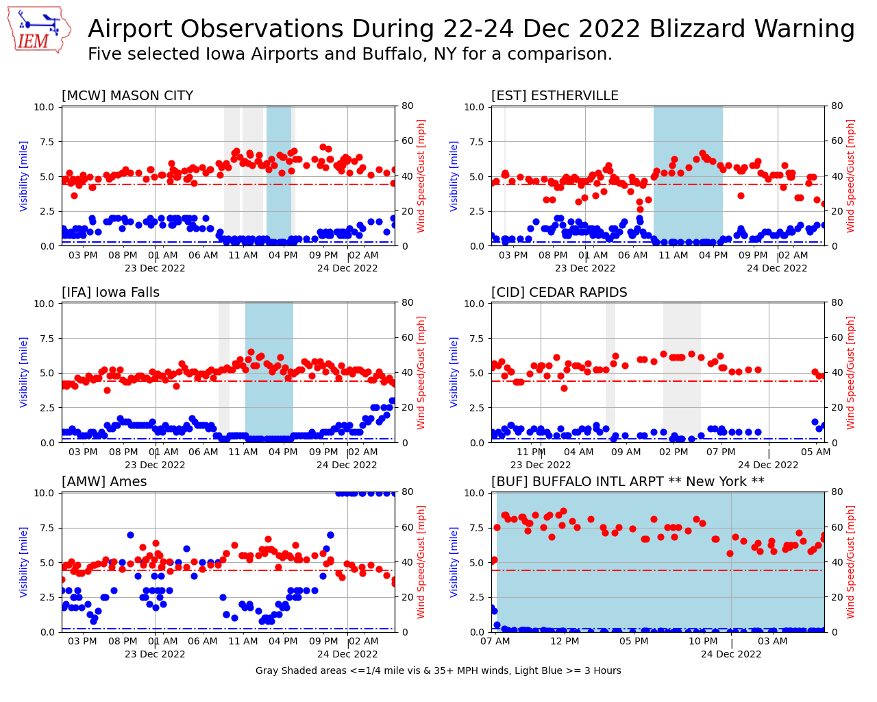
24 Dec 2022 07:09 AM
The upfront caveat for today's featured plot is that verifying Blizzard Warnings with automated weather stations is difficult. The difficulties include stations that may struggle at observing low horizontal visibility and/or have urban sheltering from blowing snow. The criterion for Blizzard Warnings also requires at least three consecutive hours with winds of at least 35 MPH and visibility values at or below a quarter mile. The Blizzard Warning for Iowa has thankfully expired this morning, so the featured chart presents a look at five selected Iowa airport weather stations along with Buffalo, NY for a wild comparison. The dashed red line show the wind requirement and dashed blue line shows the visibility requirement. Areas shaded in gray are instantly meeting both those requirements and areas shaded in blue have meet the three hour requirement. The time duration of each plot matches the duration of the Blizzard Warning for that location, except Buffalo, which is still ongoing at the time of this feature posting. For Iowa, the situation Friday afternoon was clearly the worst for the event. The visibility requirement was more difficult to meet for this event vs the wind speed. Again, caveats here as blowing snow was much more significant in rural areas. And wow, what an ongoing event for Buffalo, which is experiencing an epic Lake Effect Blizzard.
Voting: Good - 14 Bad - 3
Tags: blizzard
Generate This Chart on Website
Mon Dec 26, 2022
'22-'23 Winter Storm #9
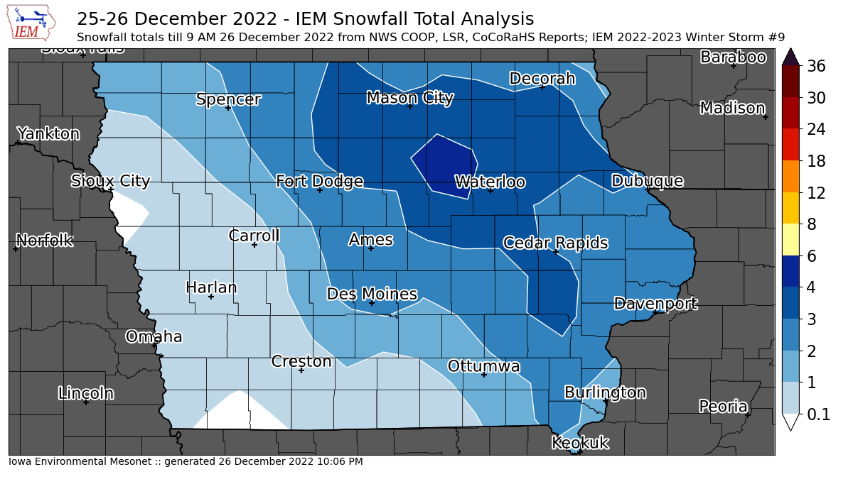
26 Dec 2022 09:12 AM
Just as we got cleaned up from the blizzard last week, a quick hitting system brought a few inches of fluff to the state overnight. The featured map shows an analysis of available reports with a patch of three inches confined to northeastern Iowa. Another cold front will sweep the state today and bring along a slight increase in winds. Hopefully not enough to significantly blow around this new fluff, but it is something to be aware of for those of you travelling today.
Voting: Good - 12 Bad - 0
Tags: winter2223
Tue Dec 27, 2022
Wrapping up 2022
27 Dec 2022 05:30 AM
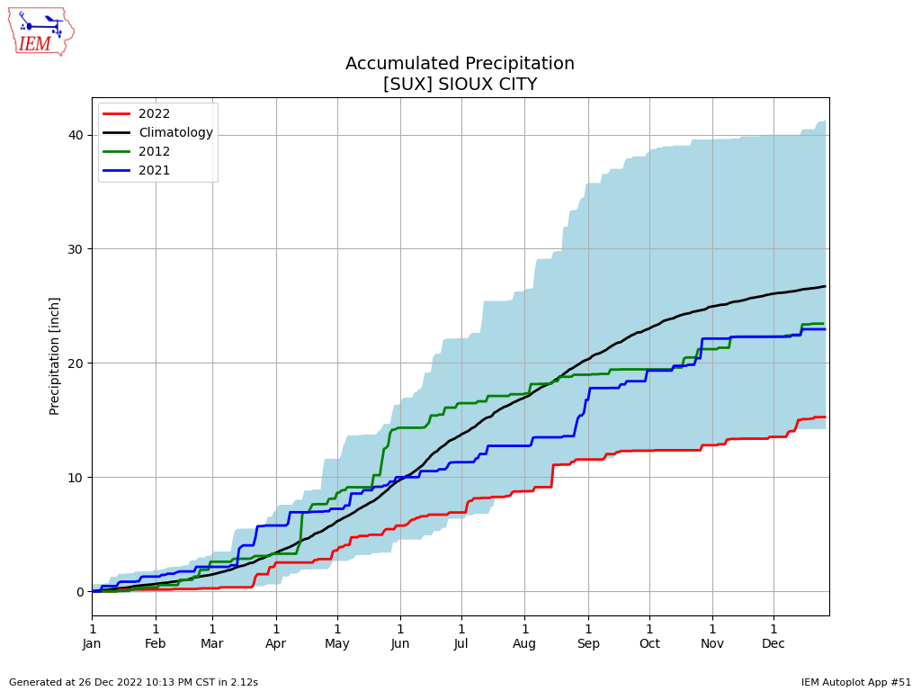
With just five days left of 2022, it is a good time to start summarizing the year that was. A significant weather story this year was the drought, that was most persistent over NW Iowa. The epicenter was Sioux City, which reached the worst drought classification of "D4". The featured chart presents the year to date accumulated precipitation along with the range of values on record and the accumulated values for last year and the drought year of 2012. The accumulated total for 2022 was at the very bottom of the range from mid July to early December. A few recent precipitation events have pushed the total above the lowest on record, but not by much.
Voting: Good - 12 Bad - 0
Tags: 2022
Generate This Chart on Website
27 Dec 2022 05:30 AM
With just five days left of 2022, it is a good time to start summarizing the year that was. A significant weather story this year was the drought, that was most persistent over NW Iowa. The epicenter was Sioux City, which reached the worst drought classification of "D4". The featured chart presents the year to date accumulated precipitation along with the range of values on record and the accumulated values for last year and the drought year of 2012. The accumulated total for 2022 was at the very bottom of the range from mid July to early December. A few recent precipitation events have pushed the total above the lowest on record, but not by much.
Voting: Good - 12 Bad - 0
Tags: 2022
Generate This Chart on Website
Wed Dec 28, 2022
Lowest in the Contiguous US
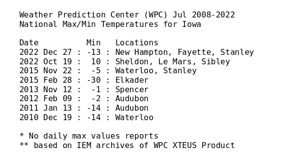
28 Dec 2022 12:01 AM
The Weather Prediction Center (WPC) issues a daily national high and low temperature product that contains their analyzed coldest and warmest temperature over the contiguous US (meaning sans Alaska, Hawaii, island territories). Three Iowa sites made this listing yesterday for the coldest temperature. The featured table presents an IEM analysis of when Iowa sites made this national listing. All of the entries are for coldest temperature over the archive period as no max temperature events were found. The reason Iowa was the coldest had to do with the combination of a fresh/fluffy snowfall, a surface high pressure system in the vicinity, and a warming western US with major pattern shift underway.
Voting: Good - 5 Bad - 0
Tags: wpc
Generate This Chart on Website
Thu Dec 29, 2022

2022 Local Storm Reports
29 Dec 2022 05:30 AM
With only three days left for 2022, it continues to be a good time to look back on the year that was. The featured chart presents a calendar of daily NWS Local Storm Reports related to severe convection. While this chart does not really put into context these numbers vs some climatology, the totals are generally paltry as one typically expects during a year plagued by drought. It is interesting to see the highest total show up on 5 March, which is likely the most significant severe weather event of the year. It was the day that featured the EF4 tornado near Winterset.
Voting: Good - 13 Bad - 1
Generate This Chart on Website
Fri Dec 30, 2022
'22-'23 Winter Storm #10
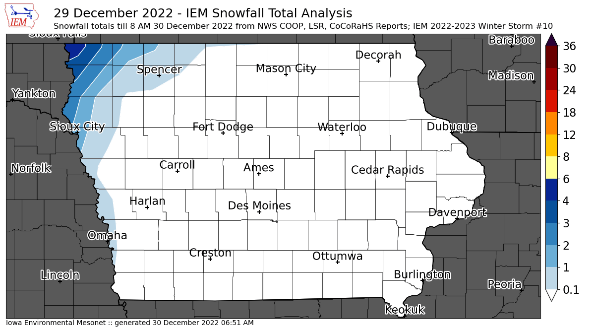
30 Dec 2022 06:55 AM
While most of the state enjoyed a spring break on Thursday with record high temperatures, extreme northwestern Iowa had snow! The featured map of available NWS and CoCoRaHS reports shows the highest totals in the 2-4 inch range with amounts quickly dropping off to the south and east. Temperatures for all of Iowa will be cooler today and into the weekend. Happy New Year!
Voting: Good - 21 Bad - 0
Tags: winter2223