September 5, 2004 Tornadoes
Brad Small Senior Meteorologist
Information from storm surveys conducted by Karl Jungbluth, Craig Cogil, and Rodney Donavon was
included in this report.
A late season tornado outbreak occurred across Iowa during the early evening hours of
Sunday September 5, 2004. The environment suggested little potential for large hail and
minimal chances of damaging straight-line winds. The greatest severe weather threat was
actually tornadoes, and that turned out to be the case. There were eight tornadoes in the Des
Moines National Weather Service Forecast Area, all F0 or F1, no reports of hail, and only one
straight-line wind report.
The environment reflected high values of both shallow and deep layer shear with only
weak to moderate instability. Figure 1 shows the modified LAPS sounding for DSM at 23z,
while Table 1 lists several of its severe weather parameters.
MLCAPE (50mb)
1036 j/kg
0-3km CAPE
168 j/kg
MLCIN (50mb)
-7 j/kg
EL 12342m
(40492
ft)
LCL 816m
(2677
ft)
LFC 977m
(3205
ft)
Freezing Lvl
14700 ft
Wet Bulb Zero
13017 ft
VGP - 4km
0.23
EHI 1km
1.4
EHI 3km
2.0
SRH 3km
310 m2/s2
SRM 1km
222 m2/s2
0-1km shear
32 kts
0-6km shear
48 kts
Figure 1 DSM Modified 23z LAPS sounding
Table 1 23z Modified LAPS Severe
Weather Parameters
Although the shear was more than adequate for supercells and organized systems,
marginal instability and low normalized cape would keep parcel accelerations relatively weak.
This combined with high freezing levels and web bulb zeros made large hail production highly
unlikely, and diminished the chances for downbursts or widespread straight-line wind events.
The environment was much more conducive for tornado development however. Several
parameters including 0-3km CAPE and its relatively high percentage of MLCAPE (16%), and

intense 0-1km shear made conditions favorable for rapid shallow parcel accelerations and
rotation. This intense low level stretching and shear, as well as accompanying low LCLs and
LFCs, were nearly ideal for mini-supercells whose mesocyclones would be low enough to aid
tornadic development.
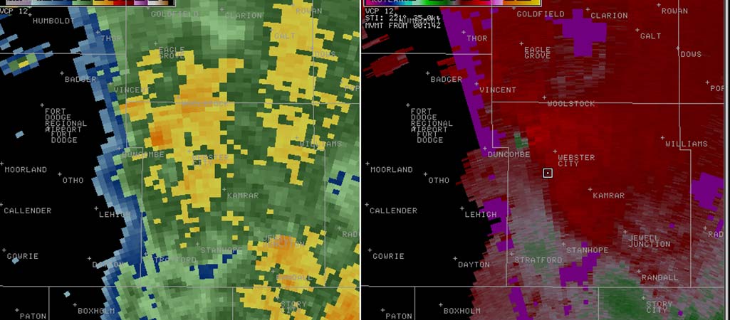
The first tornado events the Des Moines forecast area occurred in Greene County at 604
pm CDT, just south and east of Cooper, and 2 miles west of Jefferson (F0) . The strongest radar
signature was with the Cooper storm, and is shown in Figure 2. Storm Relative Velocity (SRM)
is noted in the right hand image while Reflectivity is displayed on the left. Recall that green is
motion toward the radar and red away from the radar in the SRM display, with the radar to the
southeast. Notice that reflectivities are rather low, with only a slight hint at a "hook" echo.
Figure 2 - WSR-88D 0.5° 2301Z Reflectivity (left) and Storm Relative Velocity (right). Cooper tornado.
The same storm that produced the tornadoes in Greene County then traveled northeast
toward Hamilton County. Another brief tornado then occurred with the storm 4 miles northwest
of Webster City at 715 pm CDT (F0). The radar signatures were much more subtle by this time,
with Figure 3 showing the same information as Figure 2. Notice the rather innocuous looking
reflectivity and SRM images. Only a minor circulation is noted in the SRM data. The reflectivity
would cause little or no concern at first glace with returns below 50dBZ.
Figure 3 - WSR-88D 0.5° 0014Z Reflectivity (left) and Storm Relative Velocity (right). Tornado 4 NW
Webster City.


Another long track mini-supercell moved across Union and Madison Counties, and
prompted several tornado warnings. The storm eventually produced a weak, brief tornado in
northwest Warren County at 752 pm CDT, 5 miles southwest of Norwalk near Prole (F0).
Figure 4 again shows rather innocuous looking reflectivity and SRM images with this storm.
Figure 4 - WSR-88D 0.5° 0014Z Reflectivity (left) and Storm Relative Velocity (right). Tornado near Prole.
About an hour later another stronger storm crossed northwest Lucas County into southern
Warren County with a very intense circulation noted in velocity data. National Weather Service
staffers conducted a storm survey and the only apparent and conclusive tornado damage occurred
5 miles northwest of the town of Lucas at 848 pm CDT. Figure 5 shows a very intense
circulation with a more organized reflectivity signature as well. However again note that the
reflectivity image exhibits no hook echo, and only a slight hint of an inflow notch.
Figure 5 - WSR-88D 0.5° 0146Z Reflectivity (left) and Storm Relative Velocity (right). Tornado 6 NW
Lucas.
This storm weakened, but the Prole storm continued to display moderate to strong
indications of a circulation in the lowest slice of radar data as it entered Polk County with
tornado warnings in effect. A post-event storm survey did discover tornado damage in northeast
Polk County, 8 miles east of Elkhart at 851 pm CDT (F0). Figure 6 shows similar features with
this storm circulation.
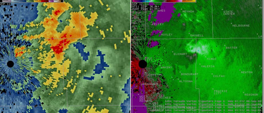

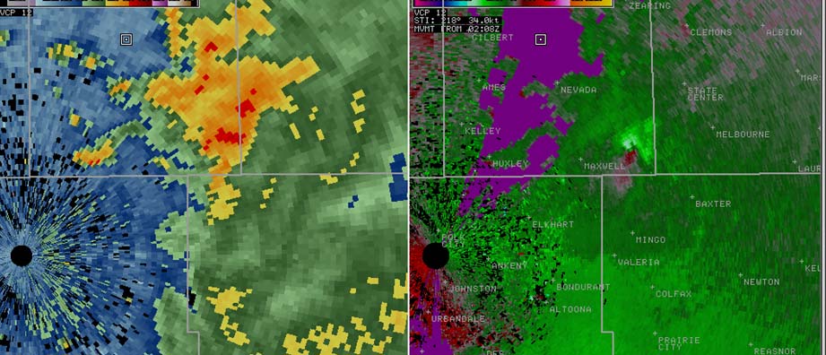

Figure 6 - WSR-88D 0.5° 0152Z Reflectivity (left) and Storm Relative Velocity (right). Tornado 8 E Elkhart.
This storm maintained intensity as it crossed into southeast Story County, continuing its
track all the way across Union, Madison, Warren, Polk and Jasper Counties. Although
conclusive tornado damage was not evident in far northwest Jasper County, the storm produced
another and slightly stronger F1 tornado just south and east of Collins at 906 pm CDT. The
radar circulation at this time was very similar to what occurred near Elkhart (Figure 7).
Reflectivity data was more organized during both of these tornado occurrences and resembled
signatures similar to what you would typically see in larger supercells.
Figure 7 - WSR-88D 0.5° 0208Z Reflectivity (left) and Storm Relative Velocity (right). Tornado just SE of
Collins.
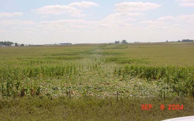
The last tornado track of the day, and surprisingly most significant, occurred just after the
storm entered Marshall County. Although there was some evidence of minor crop damage, it
was insufficient to assume that the Collins tornado remained on the ground into Marshall
County, and the track shifted more to the north as well. A more pronounced 3 mile long tornado
track started about 3 miles southwest of State Center at 927 pm CDT, ending about 3 miles
north-northwest of State Center 7 minutes later. Damage was F1 at its peak. The damage path
looked to be about a 100 feet wide and destroyed several sheds and grain bins with numerous
trees snapped. Damage pictures gathered from the National Weather Service survey and trained
spotter Jason Dodd showed distinct paths through the corn (Figures 8 and 9). Most of the
structure and tree damage had already been cleaned up before the photos were taken. Notice that


the storm had weakened considerably in both the reflectivity and velocity imagery at the time of
the tornado, but the storm continued to produce significant damage (Figure 10). The storm
ended at 929 pm CDT and was the last tornado reported for the day.
Figure 8 - 1 mile south of Highway 30, looking north (Justin Dodd)
Figure 9 - 3/4 mile east of Arney Ave, looking south from Highway 30 (Justin Dodd)
Figure 10 - WSR-88D 0.5° 0226Z Reflectivity (left) and Storm Relative Velocity (right). Tornado 3 W State
Center.
The events of Sunday September 5, 2004 should be noteworthy for several reasons. First
off, remember that tornadoes can occur in nearly any month of the year, even in September well
after what is typically known as the peak of severe weather season in Iowa. Eight different
tornadoes occurred in what could be defined as a late season outbreak (Figure 11). Secondly,
tornadoes can and do occur at night when visual identification is difficult. The NWS only
received tornado reports with two of the storms while they were in progress, with the remaining
reports based on damage which was correlated to radar signatures well after the event. Also,
conditions on this day were mainly conducive for storms producing either tornadoes or no severe
weather at all. Spotters and the general public should not be lulled into complacency because
the storms lacked large hail and substantial straight-line winds. Lastly, several of these
tornadoes occurred with less than impressive radar signatures, especially a significant track
across Eastern Marshall County, while other more impressive storms produced little or no
damage at the surface.
Figure 11 Graphic of 8 tornado locations from Sunday, September 5, 2004 in the Des Moines NWS area of
responsibility (red triangles).